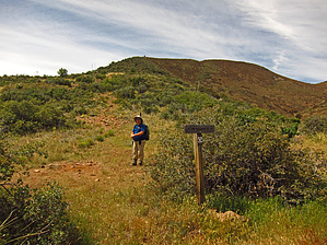
From the far northeastern "Superstition Wilderness" Two Bar Ridge Trail #119 North End- Park/TH Start, hike Trail #119 (also part of the AZT) for .28 miles before the required take off point for the balance of the .47 mile "off-trail" hike segment to summit this benchmark and SOTA (summits on the air) peak at 5268 feet.
WARNING! Hiking and outdoor related sports can be dangerous. Be responsible and prepare for the trip. Study the area you are entering and plan accordingly. Dress for the current and unexpected weather changes. Take plenty of water. Never go alone. Make an itinerary with your plan(s), route(s), destination(s) and expected return time. Give your itinerary to trusted family and/or friends.
Permit $$
None
Directions
Road
Strictly 4x4
To hike From the Phoenix area: Take US 60 East, (ie: The Superstition Freeway), east out of the valley all the way past Superior to Miami. At the intersection of US 60 and Hwy 188, take a left on Hwy 188 and head north toward Roosevelt Lake. Take Highway 188 for 23.9 miles to FS Road 83 which is signed on the west side of Hwy 188. From this point follow FR83 its 5.9 miles to the recommended TH parking at Two Bar Ridge Tr 119 North end. Initially, traveling 2.3 miles down a nicely graded dirt road will take you close to the Black Brush Ranch Headquarters. Take the signed left turn for the next 3.6 miles on a stock 4WD vehicle required road with LT (light truck) Rated Tires. This "road" will follow a wash in the beginning before beginning its climb to the trail head. Rocks and some ruts are to be expected on this road. The total elevation gain on this 5.9 mile road is 2,100 feet so there are some steep drive sections involved. For review and download/upload, please see above posted Driving Directions GPS Routes (two- the recommended route in/out via FR83 and an alternate driving route in or out via Hwy 188/FR449-J Bar Road).. It is recommended to "only" drive this alternate 4WD route IF desiring a change of area scenery.
page created by Grasshopper on Apr 13 2014 12:36 pm
 Route Editor


 From the far northeastern "Superstition Wilderness" Two Bar Ridge Trail #119 North End- Park/TH Start, hike Trail #119 (also part of the AZT) for .28 miles before the required take off point for the balance of the .47 mile "off-trail" hike segment to summit this benchmark and SOTA (summits on the air) peak at 5268 feet.