username
X
password
register
for free!
help
  
  🔥

Cimeron Mountain 5570, AZ

Guide 3 Triplogs  0 Topics
  4.7 of 5  
Fav
Wish
1
details
drive
no permit
forecast
🔥
route  
stats
photos
triplogs
topics
location
81 3 0
Statistics
tap row or icons for details
Difficulty 2.5 of 5
Route Finding 2 of 5
Distance One Way 1.15 miles
Trailhead Elevation 4,652 feet
Elevation Gain 918 feet
Accumulated Gain 918 feet
Kokopelli Seeds 4.21
 Interest Off-Trail Hiking & Peak
feature photo
Photos Viewed All MineFollowing
Inaugural Calculation on Button Tap!
12  2023-11-19
Sugar N Cimeron
pseudalpine
22  2022-11-16 wallyfrack
27  2014-04-13
Sugar N Cimeron
chumley
20  2014-04-13 FOTG
Author
author avatar Guides 16,843
Routes 17,472
Photos 24
Trips 1 map ( 6 miles )
Age 28 Male Gender
Location HAZ, TrailDEX
Associated Areas
list map done
Globe Region
Historical Weather
Trailhead Forecast
Radar Map
Expand Map
Preferred Apr, Oct, Mar, Nov
Sun  6:01am - 6:45pm
Official Route & 1 Rt
 
3 Alternative
 
Historic Fire Perimeteracres
🔥 2019 Woodbury Fire123.8k


remove free decal offer

  
Guide Needed
Publish Full Detail Guide


Use +Add above to share photos and triplogs
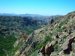
Great peak that rises north of Rough Canyon in the Superstition Wilderness.

Happy

Trails!


    Check out the Official Route and Triplogs.
    Leave No Trace and +Add a Triplog after your hike to support this local community.

    One-Way Notice
    This hike is listed as One-Way.

    When hiking several trails on a single "hike", log it with a generic name that describes the hike. Then link the trails traveled, check out the example.
    WARNING! Hiking and outdoor related sports can be dangerous. Be responsible and prepare for the trip. Study the area you are entering and plan accordingly. Dress for the current and unexpected weather changes. Take plenty of water. Never go alone. Make an itinerary with your plan(s), route(s), destination(s) and expected return time. Give your itinerary to trusted family and/or friends.

     Permit $$
    no fees or permits reported

    if incorrect tell us about it


     Directions
    or
     Road
    High Clearance possible when dry

    To Rogers Trough Trailhead
    Take US 60 east out of Apache Junction. A couple of miles past Florence Junction turn north onto Queen Valley Road and follow 1.6 miles. Turn right onto FS 357 (Hewlett Station Road) and follow about three miles to FS 172. Turn left onto FS 172 and follow this for 9.1 miles (keep an eye out to your right near the four-mile mark for a thin arch) to FS 172A.

    Turn right onto FS 172A and follow 3.8 miles to the Rogers Trough Trailhead. While an occasional abused sedan negotiates the drive, high clearance is highly recommended. Without 4WD you might be in serious trouble if it rains.

    This scenic drive wrecks havoc on passengers with weak stomachs.

    40-minute video of drive

    From PHX (I-10 & AZ-51) - 68.4 mi, 2 hours 3 mins
    From TUC (Jct 1-10 & Grant) - 102 mi, 2 hours 51 mins
    From FLG (Jct I-17 & I-40) - 213 mi, 4 hours 19 mins
    page created by chumley on Apr 13 2014 10:40 pm
     90+° 8am - 6pm kills
    helpcorrectionissue

    end of page marker