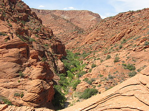
The Red Reef trail begins at the Red Cliffs campground in the Red Cliffs Desert Reserve. The easy trail initially follows the Quail Creek drainage out of the campground, shortly entering a red slickrock canyon with numerous swimming holes. This area sees heavy use by families during nice weather, but especially in spring when there is reliable flow in the creek. Continuing up stream, the best course is generally to stay in the water through the long slot (this is also the most scenic part of the hike). You can go up and around if you really hate getting wet, but routes back down into the canyon are sketchy at best. A few spots are over waist-deep, but most are only knee-deep or less. About 1.5 miles from the trailhead, the route diverts to the south (left) up an unnamed side canyon at a spot only occasionally marked by a user-created cairn - having a route loaded in your GPS may be helpful at this point.
Follow this side canyon up several dry falls and chimneys, including one with a permanent rope (not maintained - use at your own risk). This canyon leads to an area of more open slickrock. There may be some footrints and/or cairns, but if not, generally head south following the overall slope of the landscape, which will lead you to the main wash draining this area. This becomes somewhat of a slot canyon with a few minor dry falls to climb down or around - nice slickrock area. After winding through the canyon in red sand, the route meets up with the Cottonwood Wash/Trail. You can continue on the Cottonwood Wash in either direction, but this is the end of the Red Reef Trail.
When hiking several trails on a single "hike", log it with a generic name that describes the hike. Then link the trails traveled, check out the example.
WARNING! Hiking and outdoor related sports can be dangerous. Be responsible and prepare for the trip. Study the area you are entering and plan accordingly. Dress for the current and unexpected weather changes. Take plenty of water. Never go alone. Make an itinerary with your plan(s), route(s), destination(s) and expected return time. Give your itinerary to trusted family and/or friends.
To hike Take I-15 north from St. George, Utah, to Exit 22 for Leeds. At the end of the freeway off-ramp, turn right onto Old Highway 91 (now the frontage road). Travel south 2 miles and turn right after the sign for the Red Cliffs Recreation Area. Drive under the freeway and follow the paved road for 1.3 miles into the campground. There is day-use parking here.
OR, take I-15 south from Cedar City, Utah, to Exit 23 (Leeds/Silver Reef). Turn left on Silver Reef Road, then turn right onto Main Street. Travel south for 3.5 miles on Main Street, which turns into Old Highway 91. Follow the remaining directions above.
Note:
Note the exit numbers carefully depending which direction you are traveling from. Both are one-way on/off exits!
The tunnels under I-15 restrict vehicle size to less than 12 feet in height or width.
page created by autumnstars on Apr 27 2014 6:12 pm
 Route Editor


