Part of the Prescott Circle Trail, Javalina Trail #332 rises and falls over the hilly terrain of Arizona's central highlands. Exposed slopes of chaparral and pinyon-juniper woodland are interspersed with shady groves of ponderosa pine where a variety of bird calls can be heard ringing out from among the trees. There are nice views of both Thumb Butte and Granite Mountain--Prescott's most prominent landmarks. This trail is notable because it provides a route between these two features. As of July 2010, there are multiple unmarked trails on the south side of Iron Springs Road. This trail is the one that follows a portion of the old Santa Fe railroad grade, just past a locked gate.
This trail is open to hikers, horseback riders, and mountain bicyclists. Please be considerate of other users--slow down and know when to yield the trail. Refrain from using horses and bikes when the trail is wet.
Gate Policy: If a gate is closed upon arrival, leave it closed after you go through. If it is open, leave it open. Leaving a closed gate open may put cattle in danger. Closing an open gate may cut them off from water. Please be respectful, leave gates as found. The exception is signage on the gate directing you otherwise.
When hiking several trails on a single "hike", log it with a generic name that describes the hike. Then link the trails traveled, check out the example.
WARNING! Hiking and outdoor related sports can be dangerous. Be responsible and prepare for the trip. Study the area you are entering and plan accordingly. Dress for the current and unexpected weather changes. Take plenty of water. Never go alone. Make an itinerary with your plan(s), route(s), destination(s) and expected return time. Give your itinerary to trusted family and/or friends.
Only trailheads with six "amenities" have fees. Amenities are picnic tables, trash, toilet, parking, interpretive signing and security.
Directions
Road
Paved - Car Okay
To hike From downtown Prescott, travel west on Gurley Street (becomes Thumb Butte Road) for 3.4 miles to the Thumb Butte Picnic Area. Continue another 0.9 miles to the trailhead on the right. Do not block the gate. Parking is poor.
Alternately, Circle Trail #322 may be accessed from Iron Springs Road. From its intersection with Williamson Valley Road travel northwest on Iron Springs Road 1.5 miles to Granite Basin Road. Continue another 1.5 miles to the turnoff on the left. Just before the turnoff is a sign indicating that the trail crosses the roadway. Parking is fair. From here the trail can be followed northeast to the Granite Basin Recreation Area, or south towards Thumb Butte.
 Route Editor


 Part of the Prescott Circle Trail, Javalina Trail #332 rises and falls over the hilly terrain of Arizona's central highlands. Exposed slopes of chaparral and pinyon-juniper woodland are interspersed with shady groves of ponderosa pine where a variety of bird calls can be heard ringing out from among the trees. There are nice views of both Thumb Butte and Granite Mountain--Prescott's most prominent landmarks. This trail is notable because it provides a route between these two features. As of July 2010, there are multiple unmarked trails on the south side of Iron Springs Road. This trail is the one that follows a portion of the old Santa Fe railroad grade, just past a locked gate.
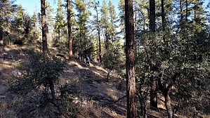


