 Route Editor

| Guide | ♦ | 21 Triplogs | 0 Topics |
details | drive | no permit | forecast | route |
stats |
photos | triplogs | topics | location |
| 191 | 21 | 0 |
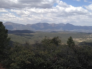
Who was "Gibson"? by kingsnake   Overview OverviewThis is an extension of the "Stewart Ridge - Payson" hike, all the way to Gibson Peak. Despite the "Stewart Ridge - Payson" description, the grab & stabs are negligible, with few catclaw or cacti (which are mostly prickly pear), while the larger brush and trees are easily negotiated. The views are well worth it: First at the rocky outcropping of Hill 5502, then on 5842-foot Gibson Peak. History Unknown. Try googling "gibson peak payson arizona" and all you will get are jillions of real estate hits. Even after filtering most of them out, no information was forthcoming. Presumably, an old settler family, as there is a "Gibson Ranch Rd."
Tanks may or may not have water. "Tank 1" (per the official route) had water in early May, whereas "Tank 2" was dry the same day, (Tank 2 was basically slime last August.) Have not laid eyes on Stewart Tank. Hike Start from the water tank on Phoenix St., following a fairly obvious foot trail south for a half-mile, to where it meets a jeep trail. The jeep trail turns northeast, past Tank 1, to an intersection at about 0.9 miles. To your right, is the return route off Gibson Peak. Turn left, proceeding to the saddle just east of Hill 5207. 1.1 mi.: At the saddle, turn right, about 175 up a faint foot trail to Stewart Ridge. From there, you basically follow the ridge to Gibson Peak, another three-something miles away. You could stay a bit lower, and follow the contour line, but you end up walking a fair bit further, in thicker brush and then face a rather steep climb when you got to Gibson Peak. No, the way to go is up & over. Plus the hills along the way are of the 100-150 foot variety. Most of your AEG will be because there are quite a few of those hills along Stewart Ridge. Once up the initial 175 feet, you will pick up a fence line, which you will roughly follow most of the way to Gibson Peak. Following the official route is not necessary -- just aim for the next high point -- but if you do, the fence will initially be to your right. Proceeding across the old burn area, you will reach the Fence 2 waymark, where the fence has collapsed; cross over so the fence is on your left. Doing so will give you an easier approach up Hill 5502. 2.4 mi.: You have reached the rock outcropping of Hill 5502. It's a minor scramble to the top of the outcropping, where you will get a sample of the awesome views you will later enjoy from the top of Gibson Peak. The burn area ends after Hill 5502, and though the brush will get thicker, it does not get very stabby. 3.3 mi.: There are several gates in fences on this hike; this is Gate 2. (I failed to waymark Gate 1.) All the gates are collapsed; don't bother playing cowboy, putting them back up. 3.9 mi. In about a half-mile, you will have climbed up Hill 5724, the final hill before the summit of Gibson Peak. The final climb to the summit is not that far, as most of your AEG has been gradual, but there is a fair amount of flat red rocks to be negotiated. 4.3 mi. The summit of Gibson Peak. Great 360° views from the Mogollon Rim, to the Sierra Anchas, a bit of Roosevelt Lake, Mount Ord, the Mazatzal Mountains, and even back to Payson itself. There is a shelter at the summit, and tucked in the wall is a flat white can, maybe 6x6x2". The can contains several geocache-like items, as well as two summit logs: The older (1987-95) in a small plastic jar, and the more recent in decent size notebook. After exploring, enjoying the views, having a snack and a refreshment, proceed west off the summit down a spur towards the jeep trail cul-de-sac. The descent is steep -- 800 feet in half a mile -- but not bad. The first half will be in brush similar to what you have so far experienced, while the bottom 400 feet will be in the open. (The bottom half is the only part visible from the cul-de-sac.) If you veer left/south, across the wash to the next spur, you may find yourself missing the cul-de-sac, and will have to backtrack to pick up the jeep trail. 4.9 mi.: The cul-de-sac is the end of a very rough jeep trail. Head northwest along it. Initially, it will be very grassy, indicating a lack of any recent use. In about a half-mile, you will begin a rather steep 250-foot climb to the east slope of Hill 5285, where Tank 2 is located. From there it is a series of 100-foot up & downs the next several miles. 7.7 mi.: You have reached the intersection where you turned left. You have closed the loop. Turn left towards Tank 1. Past the tank, in about a half-mile, turn right up the foot trail, returning to the trailhead. 8.7 mi.: Fini. Gate Policy: If a gate is closed upon arrival, leave it closed after you go through. If it is open, leave it open. Leaving a closed gate open may put cattle in danger. Closing an open gate may cut them off from water. Please be respectful, leave gates as found. The exception is signage on the gate directing you otherwise. Check out the Official Route and Triplogs. Leave No Trace and +Add a Triplog after your hike to support this local community. One-Way Notice This hike is listed as One-Way. When hiking several trails on a single "hike", log it with a generic name that describes the hike. Then link the trails traveled, check out the example. | ||||||||||||||||||||||||||||||||||||||||||||||||||||||||||||||||||||||||||||||||||||||||||||||||||||||||||||||||||||||||||||||||||||||||||||||||||||||||||||||||||||||||||||||||||||||||


