username
X
password
register
for free!
help


Cow Pies Trail, AZ

Guide 51 Triplogs  0 Topics
  3.9 of 5  
Fav
Wish
2
details
drive
permit
forecast
route  
stats
photos
triplogs
topics
location
523 51 0
Statistics
tap row or icons for details
Difficulty 1 of 5
Distance One Way 0.52 miles
Trailhead Elevation 5,054 feet
Elevation Gain 89 feet
Accumulated Gain 144 feet
Kokopelli Seeds 1
unreported if dogs are allowed
editedit > ops > dogs to adjust
feature photo
Photos Viewed All MineFollowing
Will recalculate on button tap!
5  2024-05-10
Hangover Trail
fricknaley
30  2023-06-17
Merry Go Round - Hangover Loop
John10s
14  2023-05-24
Hangover loop
trekkin_gecko
59  2023-05-24
Hangover Loop
tibber
12  2023-04-29
Hangover Trail
Nightstalker
1  2020-12-31 neilends
10  2020-11-04
Merry Hangover
fricknaley
11  2020-10-17
Merry Hangover
DixieFlyer
Page 1,  2,  3,  4,  5
Author
author avatar Guides 16,843
Routes 17,472
Photos 24
Trips 1 map ( 6 miles )
Age 28 Male Gender
Location HAZ, TrailDEX
Associated Areas
list map done
Sedona Region
Historical Weather
Trailhead Forecast
Radar Map
Expand Map
Preferred Apr, Mar, Nov, Oct
Sun  6:02am - 6:50pm
Official Route
 
25 Alternative


remove free decal offer

  
Guide Needed
Publish Full Detail Guide


Use +Add above to share photos and triplogs
Start at the Cow Pies TH on Schnebly Hill Road, 3 miles east of the end of the pavement.
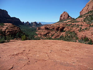
Use this trail to connect to the Hangover Trail to the North, and the Munds Wagon Trail, out the South end of the TH Parking. Explore and enjoy the Cow Pies area, a world renowned Vortex Area (If you're into that kind of thing).


  • 2021 Verde Valley Trails
    region related
    2021 Verde Valley Trails
  • 2021 Verde Valley Area
    region related
    2021 Verde Valley Area
  • 2021 Sedona Trails Map
    region related
    2021 Sedona Trails Map


Check out the Official Route and Triplogs.
Leave No Trace and +Add a Triplog after your hike to support this local community.

One-Way Notice
This hike is listed as One-Way.

When hiking several trails on a single "hike", log it with a generic name that describes the hike. Then link the trails traveled, check out the example.
WARNING! Hiking and outdoor related sports can be dangerous. Be responsible and prepare for the trip. Study the area you are entering and plan accordingly. Dress for the current and unexpected weather changes. Take plenty of water. Never go alone. Make an itinerary with your plan(s), route(s), destination(s) and expected return time. Give your itinerary to trusted family and/or friends.

 Permit $$
Red Rock Pass - may or may not be required. Go to Red Rock Pass then check "When is a Red Rock Pass Required?". If you have questions contact the Coconino forest service.


 Directions
or
 Road
High Clearance possible when dry

To hike
Cow Pies TH on Schnebly Hill Road, 3 miles east of the end of the pavement.
page created by The_Eagle on May 17 2014 4:56 pm
 90+° 8am - 6pm kills
helpcorrectionissue

end of page marker