Route Editor

| Guide | ♦ | 5 Triplogs | 0 Topics |
details | drive | no permit | forecast | route |
stats |
photos | triplogs | topics | location |
| 70 | 5 | 0 |
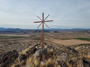
Under the Spreading Palo Verde Tree by DixieFlyer  Overview OverviewThe Palo Verde Mountains are a small range in western Pinal County, a few miles southwest of the town of Maricopa. The highpoint of the range is marked "2121" on topographic maps, indicating an elevation of 2,121 feet. Hike The parking area is south of the summit, and the summit is in view at the parking area. The route basically goes straight toward the summit, so you will be heading north on the hike up.
The recommended route is to leave the desert floor and follow a ridge that runs south of the summit to the summit. The ridge is rocky, and you'll be doing some class 2 climbing along the way. There is nothing worse than class 2 though, and there is no exposure to be encountered. The tread is generally solid, although it is quite rocky. The summit is in view the whole way on the ascent. Enjoy the nice views at the summit, and return the way that you came up. Synopsis This approximately 2-mile round trip hike packs a good punch for being such a short hike. Warning The Box Canyon Recreation Area is on the east side of the Palo Verde Mountains range, off of Hidden Valley Road. This Recreation Area encompasses almost 1,100 acres. Beginning in March 2022 the Box Canyon Shooting Range will open within the Recreation Area. The range should not interfere with hiking on the south side of the mountain, although hikers may hear gunshots coming from the range. This area has been popular with shooters for many years, and if anything the new shooting range, which is managed by the BLM, will provide more organized shooting and should enhance safety. Check out the Official Route and Triplogs. Leave No Trace and +Add a Triplog after your hike to support this local community. | ||||||||||||||||||||||||||||||||||||||||||||||||||||||||||||||||||||||||||||||||||||||||