|
tap row or icons for details
|
| Difficulty |
|
3.5 of 5 |
| Route Finding |
|
2 of 5 |
| Distance Round Trip |
|
9 miles |
| Trailhead Elevation |
|
7,532 feet |
| Elevation Gain |
|
3,269 feet |
| Avg Time Round Trip |
|
4 hours |
| Kokopelli Seeds |
|
25.35 |
| Interest Peak | | unreported if dogs are allowed
editedit > ops > dogs to adjust |
| | |
|
|
18 |
2023-05-01 |
Two NM County Highpoints |
DixieFlyer |
|
|
|
35 |
2014-05-21 | dieanotherday15 |
|
|
56 |
2012-08-04 |
|
|
| |
|
|
|
list |
map |
done |
Southwest Region |
| | |
|
| |
|
|
Historical Weather |
| Trailhead Forecast | | |
|
 |
|
|
| Preferred Jul, Jun, Aug, Sep → 10 AM |
| |
|
|
| | |
| |
Named Locations Coordinate Links
| |
|
| help future hikers |
| post a gps route now |
| | |
| |
|
|
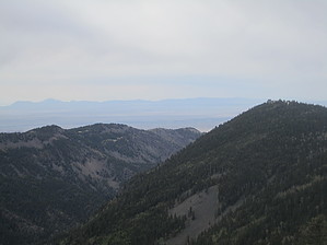
 At 10,789 feet, South Baldy is the highest point in the Madalena mountains to the southwest of Albuquerque and west of Socorro (about 100 feet higher than Sandia Crest near Albuquerque and higher than most peaks in Arizona). There are several descriptions online of hikes on the lower parts of the mountain, but no summit description to the best of my knowledge for this relatively remote, but beautiful mountain range. This route takes you up the most car-friendly, shortest route to the top, packing spectacular views and a good cardio workout. Near the summit, there is an observatory if that strikes your interest, though it's not open for viewing. After arriving at the South Baldy Trailhead, take the trail up the hill and prepare for a somewhat steep climb through pine forest for about a mile or so. Then you'll start ascending along what looks like a burned ridge before returning to the forest. The views get progressively better as you go up, though the trail narrows at points to little more than a foot or two wide. Watch your footing, especially coming down these steep slopes. At 2.9 miles, you will reach the end of the trail. From the end of the South Baldy trail at the upper trailhead, follow the dirt road another 1 mile. As you progress up the road, views become more and more spectacular until you reach the gate for the observatory. There are no restrictions on foot traffic, so continue past the gate for about .25 mi and turn right on the dirt road away from the observatory toward the peak. After about another .25 miles, you will reach the summit. Enjoy the beautiful views from the top and then turn around and come back the way you came.
test
Gate Policy: If a gate is closed upon arrival, leave it closed after you go through. If it is open, leave it open. Leaving a closed gate open may put cattle in danger. Closing an open gate may cut them off from water. Please be respectful, leave gates as found. The exception is signage on the gate directing you otherwise.
|
 Route Editor