Route Editor

| Guide | ♦ | 3 Triplogs | 0 Topics |
details | drive | no permit | forecast | map |
stats |
photos | triplogs | topics | location |
| 20 | 3 | 0 |
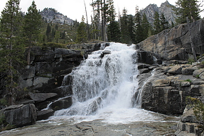
Popular Trail For A Reason by JimmyLyding The hike begins at the upper end of the parking lot with a large information kiosk and immediately turns to the right. The Bear Creek Trail begins about 100 yards up the trail while Canyon Creek Trail heads to the left. The trailhead is close to the active creek, but the trail is now about 100 feet above the water and climbing higher as it's now in the Trinity Alps Wilderness Area. The grade is gentle as ponderosa pine and Douglas fir provide a lot of shade.
The next 2 miles are less steep than before as the trail heads through small meadows near the creek, forests farther up and chaparral where the terrain becomes too steep for trees. There is a large and popular backpacker's campground at Stonehouse Gulch a few hundred yards before 6 miles. A large portion was occupied by 2 dozen members of the California Conservation Corps when I went by. The next portion shows off the improvements they've made to the trail as it switchbacks uphill for a few hundred yards. The best views of the hike are found on the next stretch as the higher elevation brings an open forest with large areas of rock. Mount Hilton, Wedding Cake and Sawtooth Mountain all loom over 3,000 feet above. The shadows are long and the wind is strong as the trail winds through small aspen before reaching a ford of Canyon Creek. The creek is not wimpy here, and crossing will involve getting wet unless you're here in August-November. I never reached the lakes when I hiked this because the creek was too big and I was 90 minutes past my turnaround time by the big crossing so take what I write next with a grain of salt. The trail winds its way through the forest for a few hundred yards before steeply climbing uphill to Lower Canyon Creek Lake 7.25 miles in. The views are spectacular here, and the trail heads uphill on the west side to Upper Canyon Creek Lake about 8 miles in. "L" Lake can be reached by taking an unofficial social trail uphill for about 1,000 feet over a mile above the upper lake. Check out the Triplogs. Note This is a moderately difficult hike. Leave No Trace and +Add a Triplog after your hike to support this local community. | ||||||||||||||||||||||||||||||||||||||||||||||||||||||||||||||||||||||||||||||||||||||||||||||