username
X
password
register
for free!
help
 This is likely a great time to hike this trail!  Check out "Preferred" months below, keep in mind this is an estimate.
  

Kanarra Creek Trail - Kanarraville Falls, UT

Guide 3 Triplogs  1 Topic
  3.5 of 5  
Fav
Wish
3
details
drive
permit
forecast
route  
stats
photos
triplogs
topic
location
15 3 1
Statistics
tap row or icons for details
Difficulty 2 of 5
Route Finding 1 of 5
Distance One Way 3 miles
Trailhead Elevation 5,626 feet
Elevation Gain 473 feet
Accumulated Gain 531 feet
Kokopelli Seeds 4.77
 Interest Perennial Waterfall & Perennial Creek
 Dogs not allowed
feature photo
Photos Viewed All MineFollowing
Inaugural Calculation on Button Tap!
11  2017-09-06 John9L
4  2014-06-02 AZLOT69
Author
author avatar Guides 16,843
Routes 17,472
Photos 24
Trips 1 map ( 6 miles )
Age 28 Male Gender
Location HAZ, TrailDEX
Associated Areas
list map done
Southwest Region
Historical Weather
Trailhead Forecast
Radar Map
Expand Map
Preferred Oct, May, Apr, Sep
Sun  6:06am - 6:56pm
Official Route & 2 Rts
 
0 Alternative


remove free decal offer

 Likely In-Season!
Guide Needed
Publish Full Detail Guide


Use +Add above to share photos and triplogs
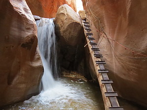
The first mile is on an old jeep trail with a few creek crossings. Then it narrows down to a creek hike to a short but sweet set of two sections of slot canyons with several waterfalls including two which require a ladder (sometimes in place) or rope assist(sometimes in place). Fun hike intro to the area. Water shoes good idea, you are going to get wet.


    Check out the Official Route and Triplogs.
    Leave No Trace and +Add a Triplog after your hike to support this local community.

    One-Way Notice
    This hike is listed as One-Way.

    When hiking several trails on a single "hike", log it with a generic name that describes the hike. Then link the trails traveled, check out the example.
    WARNING! Hiking and outdoor related sports can be dangerous. Be responsible and prepare for the trip. Study the area you are entering and plan accordingly. Dress for the current and unexpected weather changes. Take plenty of water. Never go alone. Make an itinerary with your plan(s), route(s), destination(s) and expected return time. Give your itinerary to trusted family and/or friends.

     Permit $$
    Information is listed below


     Directions
    or
     Road
    Paved - Car Okay

    To hike
    Highway 15 north of St George about 48n miles. Exit Kanarraville old highwat 91. Proceed north 4.5 miles to !00 road in Kanarraville. Turn east one mile to parking area. $10 self pay. They apparently mean it and will boot or tow your car without a visible window receipt.
    page created by AZLOT69 on Jun 03 2014 6:43 am
     90+° 8am - 6pm kills
    helpcorrectionissue

    end of page marker