Route Editor

| Guide | ♦ | 3 Triplogs | 0 Topics |
details | drive | no permit | forecast | 🔥 route |
stats |
photos | triplogs | topics | location |
| 44 | 3 | 0 |
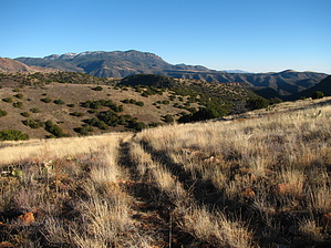
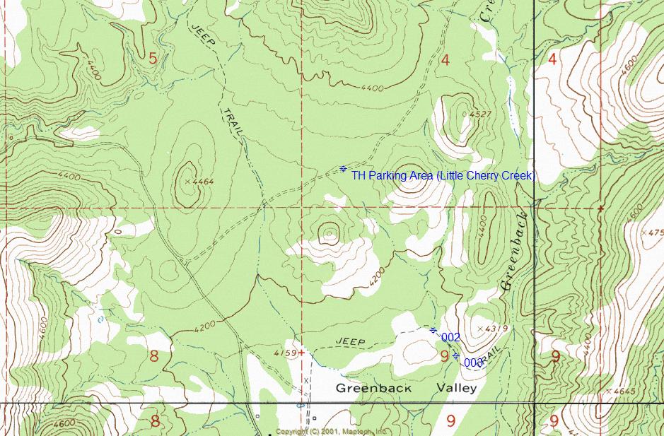
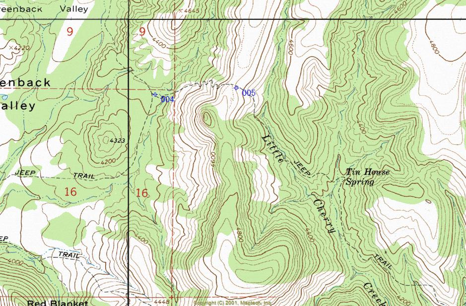
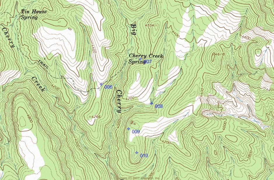
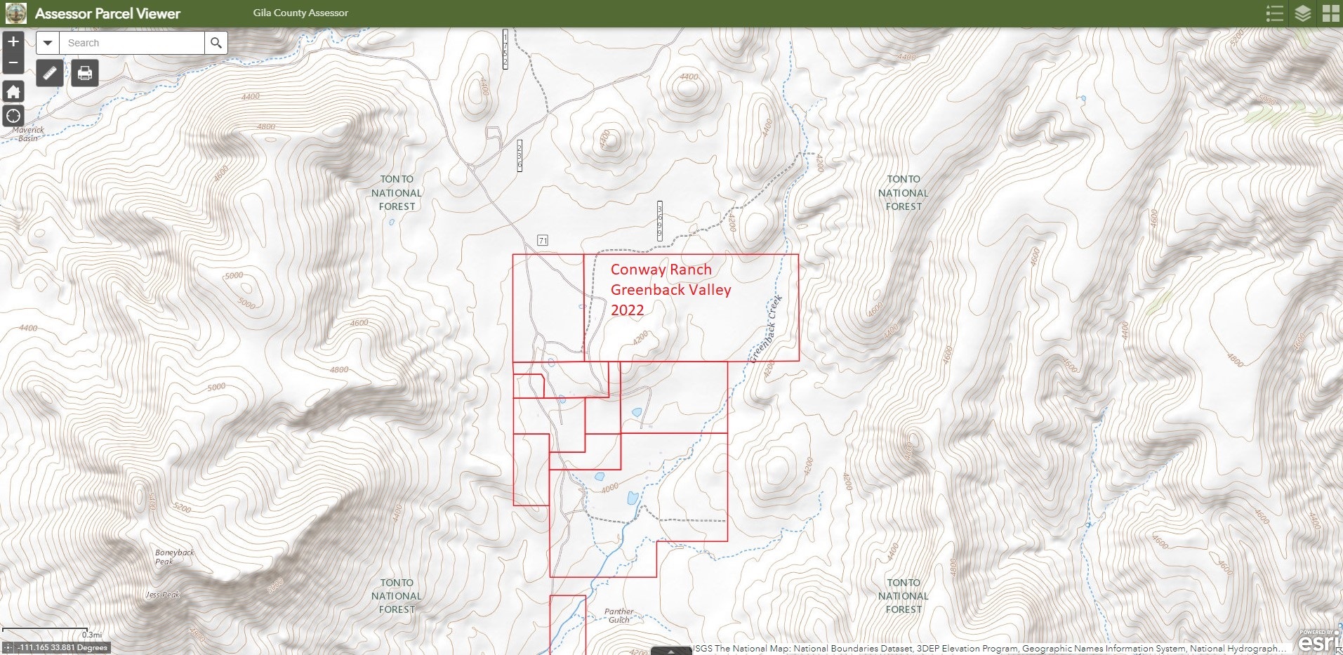
The Greenbacks Grand Tour by ssk44   2022 Update 2022 UpdateRoute update as of 2022. The initial route segment bypassing the northeast boundaries of the Conway Ranch as described is no longer valid. Original property fencing along the northeast property line does not match actual surveyed property boundaries. The current property residents are enforcing the true surveyed property boundaries and are no longer allowing access as described within this guide. Accessing the Little Cherry Creek Trail requires off-trail bypassing of the northeast Conway Ranch based on the attached Gila County Assessor Map. Do not enter areas posted as private property. Rejoin hike as described at Mark 004 (Lat 33/52/11.20/N & Long 111/7/24.21/W). Overview Little Cherry Creek is located in a remote region of the Sierra Ancha Mountains, within the Tonto National Forest. The route starts out near the Conway ranch in the Greenback Valley area and heads to the southeast along the base of the Greenback Peak. The route ends on a secluded ridge on the edge of the northern reaches of the Salome Wilderness, overlooking Salome Creek with incredible views. This route was once an old jeep trail that has since eroded into primarily a hiking and horseback corridor. Old rugged roadbeds like this make excellent hiking routes for accessing isolated remote areas.
This route is very remote and completely deserted most seasons of the year, with the only exception being the month of October. There are deer hunts throughout October, and this area is very popular. October is the only month that I would advise not choosing to come here unless you want to run into hunters and quads. Outside of October, count on having it all to yourself. For this hike, I went with a good friend and fellow HAZ member, Fred K., and his amazing Australian Shepard Nicki that join me on many of my trips. The hike, as posted, starts out at a small corral on the north side of FR236A. It is important that you do not enter the private property of Conway ranch, and all gates that access their land are well marked for this reason. The initial segment of this hike heads to the southeast through Greenback Valley, skirting the boundaries of the private land. You will begin the hike by going through a small damaged gate at the backside of a fenced area directly across from where you have parked. From this point, you will be walking along a narrow open area in the brush that follows a sand drainage. Within a short period of time, the narrow side drainage will enter a larger sand wash Mark 002 (Lat. 33 degrees/52'/42.85"/N & Long. 111 degress/7'/53.41"/W). Follow this main sand wash to the southeast until you reach an easily recognized narrow jeep trail exiting to the left side Mark 003 (Lat. 33 degrees/52'/38.45"/N & Long. 111 degrees/7'/48.76"W). This is where the main segment of the hike begins. The route is easy to follow, and basic compass and topo map reading skills will keep you on track for the remainder of the trip. Along the route, you will come across two springs, with the first being Tin House and the second being Cherry Creek. Both of these springs have historically had good flow and will usually run above ground along the main creek drainages during most seasons of the year. The trail stays on the hills above Little Cherry Creek most of the way, with many up-and-down sections providing lovely views along the hike. Fall colors can be very nice near the spring areas and along many segments of the canyons along the route. Just before you reach Cherry Creek Spring, you will cross a saddle. At this saddle, there will be a turn heading up onto a large mesa that is not shown on any maps Mark 006 (Lat. 33 degrees/51'/20.82"/N & Long. 111 degrees/5'/46.47"/W). You will want to continue on the trail heading down from the saddle towards the spring. The drainage heading south from the spring is Big Cherry Creek, which eventually intersects Salome Creek. From Cherry Creek Spring, the trail will again climb up onto another saddle and end towards the bottom of a creek drainage just south of the saddle Mark 008 (Lat. 33 degrees/51'/12.53"/N & Long. 111 degrees/5'/20.63"/W). The remaining segment from the saddle goes through a small meadow and is faint due to grass overgrowth. You're almost there with only one short and manageable bushwhack climb to go. From the bottom of the creek where the two drainages meet, as shown on topo maps, climb straight up to the top of the ridgeline overlooking Salome Creek. This ridgeline is the boundary of the Salome Wilderness. Just a short distance west from where you have climbed up from the bottom is an amazingly steep and jagged rock bluff that you have to walk out to while you are there Mark 009 (Lat. 33 degrees/51'/1.67"/N & Long. 111 degrees/5'/32.37"/W). Once on the ridgeline, you can hike southwest out to a rocky point overlooking Big Cherry Creek or northeast towards the eastern slopes of Greenback Peak. See maps for locations of GPS waypoints described in the text. Well, there you have it. Little Cherry Creek Trail is basically the grand tour of the Greenback Peak and Greenback Valley area with a great closing finale ridgeline overlooking an extremely remote area of the Salome Wilderness. This area is referred to by many as "The Greenbacks". The entire route offers great views from start to finish, with many points of interest along the way to explore. For those truly desiring remote solitude, it doesn't get much better than this. The surrounding mountains and canyons are vastly rugged with beautiful and jagged red rock cliffs. Hiking this decaying roadbed is a unique and manageable way to access a seldom visited, very special area. You won't be disappointed. Gate Policy: If a gate is closed upon arrival, leave it closed after you go through. If it is open, leave it open. Leaving a closed gate open may put cattle in danger. Closing an open gate may cut them off from water. Please be respectful, leave gates as found. The exception is signage on the gate directing you otherwise.
Check out the Official Route and Triplogs. Note This is a moderately difficult hike. Leave No Trace and +Add a Triplog after your hike to support this local community. | ||||||||||||||||||||||||||||||||||||||||||||||||||||||||||||||||||||||||||||||||||||||||||||||||||||||||