username
X
password
register
for free!
help
 This is likely a great time to hike this trail!  Check out "Preferred" months below, keep in mind this is an estimate.
  

Capitol Gorge, UT

Guide 5 Triplogs  0 Topics
  2.8 of 5  
Fav
Wish
1
details
drive
permit
forecast
route  
stats
photos
triplogs
topics
location
7 5 0
Statistics
tap row or icons for details
Difficulty 1.5 of 5
Distance One Way 2.25 miles
Trailhead Elevation 5,537 feet
Elevation Gain -192 feet
Accumulated Gain 43 feet
Kokopelli Seeds 2.39
 Interest Historic & Seasonal Creek
 Dogs not allowed
feature photo
Photos Viewed All MineFollowing
Inaugural Calculation on Button Tap!
14  2022-10-12
Golden Throne & Capitol Gorge
trekkin_gecko
3  2018-07-17 Jim
4  2014-06-20 AZLOT69
Author
author avatar Guides 16,832
Routes 17,471
Photos 24
Trips 1 map ( 6 miles )
Age Male Gender
Location HAZ, TrailDEX
Associated Areas
list map done
Central Region
Historical Weather
Trailhead Forecast
Radar Map
Expand Map
Preferred Oct, Apr, May, Mar
Sun  6:38am - 5:40pm
Official Route
 
0 Alternative


remove free decal offer

 Likely In-Season!
Expand Map
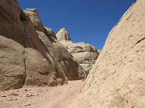
This trail follows the original highway through Capitol Reef. It was built to avoid the many crossings of the Fremont river. Barely wide enough for two wagons to pass it continued to be used by modern traffic until 1962 when the new highway 24 was constructed. You have to use your imagination to consider this a road now after many flash floods, the canyon has changed considerably. At the park boundary there is a broken down 1930 ish car rusted out. Painted on the door is " Scenic ahead, Capitol Reef Monument."


2018-07-14 HAZ_Hikebot
  • Fruita Area Map and Guide
    area related
    Fruita Area Map and Guide
  • Fruita Area Map and Guide - 2
    area related
    Fruita Area Map and Guide - 2


Check out the Official Route and Triplogs.
Leave No Trace and +Add a Triplog after your hike to support this local community.

One-Way Notice
This hike is listed as One-Way.

When hiking several trails on a single "hike", log it with a generic name that describes the hike. Then link the trails traveled, check out the example.
WARNING! Hiking and outdoor related sports can be dangerous. Be responsible and prepare for the trip. Study the area you are entering and plan accordingly. Dress for the current and unexpected weather changes. Take plenty of water. Never go alone. Make an itinerary with your plan(s), route(s), destination(s) and expected return time. Give your itinerary to trusted family and/or friends.

 Permit $$
NPS

Capitol Reef National Park
$$ per Vehicle, good for Seven Days - View Information


 Directions
or
 Road
FR / Dirt Road / Gravel - Car Okay

To hike
Take Scenic Drive 10 miles south from the visitor center to the end of the road and the trail head.
page created by AZLOT69 on Jun 20 2014 3:42 pm
helpcorrectionissue

end of page marker