 Route Editor

| Guide | ♦ | 10 Triplogs | 0 Topics |
details | drive | permit | forecast | route |
stats |
photos | triplogs | topics | location |
| 211 | 10 | 0 |
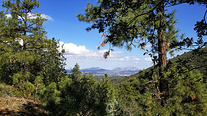
  This is a recently built extension to the Ranch Trail #62 which goes from the Watershed Trail trailhead on Senator Highway to its junction with the Seven Mile Gulch Trail. It is part of the Prescott Circle Trail and takes that trail off the motorized Watershed and Seven Mile Gulch Trails. It is a single track that winds around the contours of the hills on its rolling climb to the previously mentioned junction. AEG is 652' northbound and 324' southbound. It is easy to follow as there are no other junctions with other trails. At the junction near the Seven Mile Gulch Trail (N34 30.673 W112 25.297), you can go left to continue on the Prescott Circle Trail or right to reach the Seven Mile Gulch Trail after passing through a "step over" gate. There is a trail that goes straight, but I didn't explore. This is a recently built extension to the Ranch Trail #62 which goes from the Watershed Trail trailhead on Senator Highway to its junction with the Seven Mile Gulch Trail. It is part of the Prescott Circle Trail and takes that trail off the motorized Watershed and Seven Mile Gulch Trails. It is a single track that winds around the contours of the hills on its rolling climb to the previously mentioned junction. AEG is 652' northbound and 324' southbound. It is easy to follow as there are no other junctions with other trails. At the junction near the Seven Mile Gulch Trail (N34 30.673 W112 25.297), you can go left to continue on the Prescott Circle Trail or right to reach the Seven Mile Gulch Trail after passing through a "step over" gate. There is a trail that goes straight, but I didn't explore.Gate Policy: If a gate is closed upon arrival, leave it closed after you go through. If it is open, leave it open. Leaving a closed gate open may put cattle in danger. Closing an open gate may cut them off from water. Please be respectful, leave gates as found. The exception is signage on the gate directing you otherwise. Check out the Official Route and Triplogs. Leave No Trace and +Add a Triplog after your hike to support this local community. One-Way Notice This hike is listed as One-Way. When hiking several trails on a single "hike", log it with a generic name that describes the hike. Then link the trails traveled, check out the example. | |||||||||||||||||||||||||||||||||||||||||||||||||||||||||||||||||||||||||||||||||||||||||||||||||||||||||||||||||||||||||||||||||||||||||||||||||||||||||||||


