South Fort - Castle Creek Wilderness, AZ | HikeArizona
 
   🔥

South Fort - Castle Creek Wilderness, AZ

Guide 9 Triplogs Mine 0 0 Topics
 
3.2 of 5 
Fav
Wish
0
details
drive
permit
forecast
🔥
route  
stats
photos
triplogs
topics
location
85 9 0
HAZ reminds you to respect the ruins. Please read the Archaeological Resources Protection Act of 1979 & Ruins Etiquette
Statistics
tap icons for details
Difficulty 1 of 5
Route Finding 1 of 5
Distance Round Trip 1.7 miles
Trailhead Elevation 6,435 feet
Elevation Gain 359 feet
Accumulated Gain 390 feet
Avg Time Round Trip 1 hour
Kokopelli Seeds 3.65
 Interest Ruins
 Backpack Possible & Connecting
feature photo
Photos Viewed All MineFollowing
Will recalculate on button tap!
17  2019-04-20
Horsethief Basin East Fort South Fort Loop
Nightstalker
42  2017-04-29
Horsethief Basin East Fort South Fort Loop
Nightstalker
12  2016-08-06
Horsethief Basin East Fort South Fort Loop
Nightstalker
11  2016-04-16
Bradshaws Fort Loop
Hansenaz
5  2015-05-27 AZWanderingBear
45  2015-05-17
Horsethief Basin East Fort South Fort Loop
Nightstalker
10  2014-06-28
Lane Mtn - Milk Ranch - Willow Springs Loop
joebartels
15  2014-06-28
Lane Mountain - Willow Spring Loop
The_Eagle
Page 1,  2
Author
author avatar Guides 27
Routes 61
Photos 2,620
Trips 700 map ( 4,689 miles )
Age 67 Male Gender
Location Phoenix, AZ
Associated Areas
list map done
Prescott Region
Historical Weather
Trailhead Forecast
Radar Map
Expand Map
Preferred Oct, Apr, May, Sep
Seasons   Spring to Autumn
Sun  6:43am - 6:35pm
Official Route
 
5 Alternative
 
 Water
Historic Fire Perimetersacres
🔥 2021 Tiger Fire36.1 mi*
🔥 2008 Lane 2 Fire27.4 mi*
🔥 View (All) - over Official Route 🔥
*perimeter length in miles
Nearby Area Water
[ View More! ]
Flora  Nearby
Geology  Nearby
Named place  Nearby
no photo labels yet
+Add > Photos to this Guide
then label as applicable
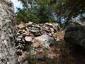
Fortifying Views
by AZWanderingBear

 
Overview
A short climb to Unimpressive ruins with Extraordinary Views!

Warning
The drive from Crown King to the trailhead is on a seldom maintained dirt road and may be closed during the winter months. 4-wheel drive is not required, but moderate clearance is.
History
Like the nearby East Fort, South Fort is a Hohokam site dating back to approximately 1300 AD. It is one of many hilltop sites that form a network with each site being visible to at least one other. The sites stretch from the northern Phoenix Valley, across the Bradshaws to Prescott and down to Wickenburg. Archaeologists are not certain of the purpose of this extensive network.

Hike
You may park at Coal Camp and walk up the old Jeep trail to the east or attempt to drive the rocky and rough trail as far as you dare. Either way, you are going uphill for 0.6 miles before turning sharply right to proceed southwest on a footpath to the rocky outcrop that hosts South Fort. Along the way, you will pass a very nice camp spot on your left set back in a stand of large pines. The setting is almost park-like. Manzanita, oak, and the occasional alligator juniper make up the remainder of the forest here. Scattered wildflowers are present in season. Keep your eyes open for deer and other wildlife. Many species call this area home.

The final leg of the hike up to the Fort crosses a fence marking the Castle Creek Wilderness Boundary. Ahead you'll see a large rock outcropping and the single rock wall that remains of the ruin. The views south as simply spectacular. Slightly west is a huge granite boulder precariously perched on the edge of the ridge.

Time permitting, the Willow Springs trail goes southeast and the rugged Jim Creek trail goes south out of Coal Camp. Or you could just head back to Crown King for a beer and burger.

Water Sources
Water is available on the drive in at the Ranger Station, Hazlett Hollow Campground, and Turney Group Campground (may be turned off in winter months).

Camping
Nearby Hazlett Hollow Campground is open from Spring through Fall. Multitudes of dispersed camping sites are available.

Check out the Official Route and Triplogs.

Leave No Trace and +Add a Triplog after your hike to support this local community.

2015-06-02 AZWanderingBear
    WARNING! Hiking and outdoor related sports can be dangerous. Be responsible and prepare for the trip. Study the area you are entering and plan accordingly. Dress for the current and unexpected weather changes. Take plenty of water. Never go alone. Make an itinerary with your plan(s), route(s), destination(s) and expected return time. Give your itinerary to trusted family and/or friends.

     Permit $$
    None

    Prescott Forest
    Prescott National Forest Pass

    Only trailheads with six "amenities" have fees. Amenities are picnic tables, trash, toilet, parking, interpretive signing and security.


     Directions
    or
    or
     Road
    FR / Jeep Road - Car possible when dry

    To hike
    From Phoenix take I-17 north to the Bumble Bee Exit 248. Follow the Crown King dirt road 27.5 miles to Crown King. Continue through Crown King along the Senator Highway for 0.5 miles and turn left on Horse Thief Road. Follow Horse Thief Road 10 miles to the gate for the Horsethief Fire Tower. Stay left at the road up to the fire tower and continue .85 miles to Coal Camp and the end of Horse Thief Road.
    page created by The_Eagle on Jun 02 2015 3:45 pm
    helpcorrectionissue

    end of page marker