Overview
This little hike is on the grounds of the Little America hotel. It provides an opportunity to stretch your legs and enjoy a pine forest, likely some squirrels, and lava rocks.
Hike
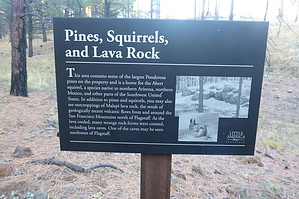
The trail begins just east of the pool. Signs along the well-graded and graveled path inform the hiker that he or she is traveling through a pine forest that was part of a fire in 2010. Almost no signs of the fire remain, indeed the area looks much like a park. Expect to see Abert's Squirrels along the trail. They are medium-sized, have cute little tufted ears, and feed exclusively on the Ponderosa Pines along the trail.
The trail offers 2 loops. The A loop is approximately 1.65 miles. If you combine both loops into a figure 8 the total distance is almost 3 miles with a total elevation change of 440 feet. The western leg of the A loop runs along and just below an ancient lava flow. The southern intersections of the loops provide a nice vantage point for the Rio de Flag, a small stream that runs through Flagstaff. Deer are often spotted in the mornings or evenings grazing in the riparian area.
You will hear traffic noise from the nearby I-40, but it is easy to forget you are this close to the city as you stroll this pleasant little trail.
WARNING! Hiking and outdoor related sports can be dangerous. Be responsible and prepare for the trip. Study the area you are entering and plan accordingly. Dress for the current and unexpected weather changes. Take plenty of water. Never go alone. Make an itinerary with your plan(s), route(s), destination(s) and expected return time. Give your itinerary to trusted family and/or friends.
Permit $$
None
Directions
Road
Paved - Car Okay
To hike From Flagstaff go east on I-40 and take 198. Turn east onto Butler Ave and then into the Little America parking lot. The trail begins near the swimming pool.
page created by DarthStiller on Oct 22 2014 7:01 pm
 Route Editor

 PRIVATE ACCESS ONLY