Route Editor

| Guide | ♦ | 47 Triplogs | 0 Topics |
details | drive | no permit | forecast | route |
stats |
photos | triplogs | topics | location |
| 476 | 47 | 0 |
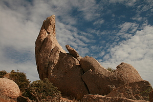
McDowells Prime Cut by cherieb  Overview OverviewLocated in the McDowell Sonoran Preserve, the Hog Heaven Hikers Climbers Loop provides access to some remote rock climbing areas of interest to rock climbers and hikers alike. The route follows the official Climber Access Routes approved by the City of Scottsdale City Council in 2011 and are maintained by the local climbing community and volunteers from the McDowell Sonoran Conservancy. This loop can be done either clockwise or counterclockwise. But because of the beauty of the unfolding scenery, many prefer the described clockwise movement. Primarily designed for rock climbers, only hikers with strong route-finding skills should attempt this classic adventure. Hike Begin at the Tom’s Thumb Trail Head (WP 1). Hike along the Tom’s Thumb Trail a few hundred yards to the intersection with the Mesquite Canyon Trail (WP 2). Turn left and hike southeast to the intersection with the Feldspar Trail (WP 3). A further left turn on Feldspar for 100 feet and then a right along the Mesquite Canyon Climber Access Route (signed – WP 4) begins your hike up the neat canyon. This Climber Access Route goes by climbing crags such as Girlie Man and Sven Towers, and Hog Heaven.
WP 10 is on the northern moraine of the Marcus Land Slide, which came down from the hill above. Cross the valley to WP 12, where you begin your upward ascent. There is a little scrambling involved making your way through the boulders but keep looking for cairns (Please leave them where you find them. They are sanctioned as part of the climber access routes by the City and help keep folks from developing “use trails” that would degrade the environment.) The following set of waypoints (WP 13 through 16) mark various climber access points of interest. Generally, you will hike up to the bottom of the 200 foot high Main Wall of Hog Heaven and then contour a little further south until under the Upper Wall above you on the broad ridgeline. Scramble and zig-zag uphill, staying on the cairned trail until you take a final scramble up and over some boulders below the right-hand end of the Upper Wall itself. The next phase of the ascent is to work right around the Upper Wall and then back to the south to pass on the east side of the Thumbnail (WP 16). Enjoy your ascent. The views are rewarding. The trail climbs up the ridge above the Thumbnail until dipping a short distance on the ridge's south side. It then ascends back to the ridgeline, moves through some boulders to the north side, and then switches back to the south through a notch with a short slippery slope beneath. Contour around the ridgeline crest again moving westward, and generally follow the ridgeline, occasionally passing obstacles on the south. A final venture on the south flank of the ridge and ascent back to the weather station/radio facility takes you to the top of East End, the highest point in the McDowell Mountains. Surveyors have placed multiple USGS markers on the summit rocks. On the accompanying route map, this area is indicated as WP 17. To continue the loop, descend to the north directly from the weather station. Beware of the slippery decomposed granite over slick bedrock! WP 18 is the saddle just east of the main Tom’s Thumb Trail. Descend the route to WP 21, which is on the main Tom’s Thumb Trail. If completing the loop, take a right and hike back to the Trail Head. A larger adventure can take a left on the Tom’s Thumb trail past the East End Trail intersection, and then following the signed spur trail to Tom’s Thumb, continue past Tom’s Thumb itself, heading west along the ridgeline. A similar climber access route descends the west arm of Tom’s Thumb cirque past climbing areas Lost Wall and Fort McDowell to reconnect with the Tom’s Thumb Trail at TT3 emergency marker. The loop, as described, is about 4.35 miles. To add the west loop would take another couple of miles and accompanying route-finding abilities. Check out the Official Route and Triplogs. Leave No Trace and +Add a Triplog after your hike to support this local community. | ||||||||||||||||||||||||||||||||||||||||||||||||||||||||||||||||||||||||||||||||||||||||||||||||||||||||||||||||||||||||||||||||||||||||||||||||||||||||||||||||||||||||||||||||||