username
X
password
register
for free!
help


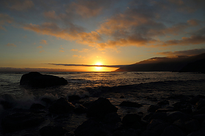
Mill Creek Picnic Area - Big Sur Coastline, CA

Guide 3 Triplogs  0 Topics
  3 of 5  
Fav
Wish
0
details
drive
no permit
forecast
map
stats
photos
triplogs
topics
location
0 3 0
Statistics
tap row or icons for details
Difficulty 0.5 of 5
Distance Round Trip 0.35 miles
Trailhead Elevation 36 feet
Elevation Gain 25 feet
Accumulated Gain 35 feet
Kokopelli Seeds 0.53
 Interest Perennial Creek
feature photo
Photos Viewed All MineFollowing
208  2015-08-23
Big Sur Coastline CA Redux - August 2015
Randal_Schulhaus
151  2014-08-18
Big Sur Coastline - August 2014
Randal_Schulhaus
56  2014-07-12
Big Sur Coastline
Randal_Schulhaus
Author
author avatar Guides 16,843
Routes 17,472
Photos 24
Trips 1 map ( 6 miles )
Age 28 Male Gender
Location HAZ, TrailDEX
Associated Areas
list map done
Central Coast Region
Historical Weather
Trailhead Forecast
Expand Map
Preferred Apr, Nov, May, Oct
Sun  5:40am - 6:29pm
0 Route
 
0 Alternative


remove free decal offer

 
Guide Needed
Publish Full Detail Guide


Use +Add above to share photos and triplogs
A hidden nook along the coast with restrooms and a couple of picnic tables. Throw in the rocky beach as a bonus!

Happy

Trails!


    Check out the Triplogs.
    Leave No Trace and +Add a Triplog after your hike to support this local community.
    WARNING! Hiking and outdoor related sports can be dangerous. Be responsible and prepare for the trip. Study the area you are entering and plan accordingly. Dress for the current and unexpected weather changes. Take plenty of water. Never go alone. Make an itinerary with your plan(s), route(s), destination(s) and expected return time. Give your itinerary to trusted family and/or friends.

     Permit $$
    None


     Directions
    or
     Road
    Paved - Car Okay

    To hike
    page created by Randal_Schulhauser on Jul 14 2014 7:26 pm
     90+° 8am - 6pm kills
    helpcorrectionissue

    end of page marker