Route Editor

| Guide | ♦ | 1 Triplog | 0 Topics |
details | drive | permit | forecast | route |
stats |
photos | triplog | topics | location |
| 4 | 1 | 0 |
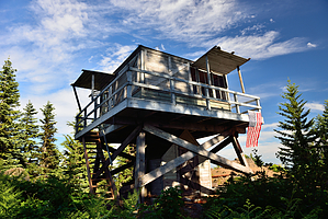
Wheres the Creek? by keepmoving Cool Creek Trail climbs a ridge from Still Creek Road to Devils Peak Lookout Tower. It is one of the 3 routes that access the old lookout. While the other routes either require a 4x4 to access (Devils Peak Trailhead near Kinzel Lake) or a full day hike (16 miles round trip using Hunchback Mountain Trail), Cool Creek Trail requires neither. Hike From the trailhead along Still Creek Road, the trail plunges into the forest and begins to ascend the ridge. The trail is fairly unrelenting and follows the same grade for almost its entire length to the lookout tower. If the trail feels too steep for you, you may want to turn back now. Fortunately, the trail is shielded from the midday sun by a thick canopy of trees that helps keep you cool.
As you work your way up the mountain, you will be treated to several false summits before finally reaching the Hunchback Ridge Trail at mile 3.6. Turn right here and follow the trail for another 100 yards to another junction with the Hunchback Ridge Trail where you will now turn left and wind the final 100 yards to the summit. Take in the views and enjoy the abandoned lookout tower, before making the steep descent back to the trailhead. Water Sources While named after a creek, the trail is dry for much of its length. I encountered two small creeks running over the trail about halfway to the lookout, however it looks like they may dry up during the summer. A sign in the lookout tower mentions a spring a 1/4 mile down the Hunchback Ridge Trail, but I have never personally checked it and don't know how reliable it is. Check out the Official Route and Triplog. Note This is a moderately difficult hike. Leave No Trace and +Add a Triplog after your hike to support this local community. | ||||||||||||||||||||||||||||||||||||||||||||||||||||||||||||||||||||||||||||||||||||||||||||||||