 Route Editor

| Guide | ♦ | 29 Triplogs | 0 Topics |
details | drive | no permit | forecast | 🔥 route |
stats |
photos | triplogs | topics | location |
| 324 | 29 | 0 |
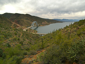
Roose Garden by PrestonSands  Overview OverviewThe Thompson Trail #121, a part of the Arizona Trail, is a short connector route that travels up and over Sonoran desert hillsides between the Roosevelt Dam area and forest road #341. Highlights of the Thompson Trail are the continuous views of Roosevelt Lake and the Sierra Ancha and Mazatzal ranges. The simplest way to access the Thompson Trail is via the 0.25-mile Cemetery Trail from the Cemetery Trailhead; however, this description starts at the south end of the Thompson Trail, where it meets forest roads 1080 and 341. A recent trail realignment has extended the length of the Thompson Trail to 2.9 miles.
From its starting point at the junction of forest roads 1080 and 341, the Thompson Trail heads west across a desert hillside before turning north to descend a rocky ridge, where it meets the Cemetery Trail at 0.6 miles 33.66555, -111.13771. A trail sign marks the junction. The Thompson Trail leaves the trail junction heading west, crossing two small drainages, before passing an old trail alignment that doubles back to head down canyon. Stay on the new alignment, which continues southwest up the canyon. At 1.3 miles, the Thompson Trail reaches a saddle, where it turns north to descend into a catclaw filled canyon. Upon reaching the canyon floor, the trail crosses over to the west side of the dry creek bed, where it makes a hard right to continue down the canyon. At about 1.7 miles, the trail makes a hard turn to the west (left) at a signpost and cattle tank (33.66692 N, 111.14403 W) to begin climbing out of the canyon. The trail winds past a wonderful saguaro grove before reaching a high saddle overlooking Government Hill at 2.3 miles. From this high saddle, the Thompson Trail wraps around the top of a steep canyon while descending to its final saddle, directly above Government Hill. From this last saddle, the trail quickly switchbacks down to highway 188. The trail passes through a green metal gate and terminates at 2.9 miles, next to a large road cut and highway bridge, at the junctions of highways 88 and 188. A trail sign marks this end of the trail (33.67321 N, 111.15219 W). Gate Policy: If a gate is closed upon arrival, leave it closed after you go through. If it is open, leave it open. Leaving a closed gate open may put cattle in danger. Closing an open gate may cut them off from water. Please be respectful, leave gates as found. The exception is signage on the gate directing you otherwise. Check out the Official Route and Triplogs. Leave No Trace and +Add a Triplog after your hike to support this local community. One-Way Notice This hike is listed as One-Way. When hiking several trails on a single "hike", log it with a generic name that describes the hike. Then link the trails traveled, check out the example. | |||||||||||||||||||||||||||||||||||||||||||||||||||||||||||||||||||||||||||||||||||||||||||||||||||||||||||||||||||||||||||||||||||||||||||||||||||||||||||||||||||||||||||||||||||||||||||||||||||||||||


