 Route Editor

| Guide | ♦ | 4 Triplogs | 0 Topics |
details | drive | permit | forecast | 🔥 route |
stats |
photos | triplogs | topics | location |
| 68 | 4 | 0 |
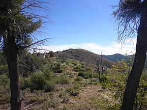
Beans, Beans, They're Good For Your Heart by kingsnake   Overview OverviewLoop hike from the White Spar Campground, just south of Prescott, up a pleasant little canyon to the west flank of the Bean Peaks -- actually two small hills -- traversing the crest of the ridge, checking out some old mines, down to Upper Goldwater Lake, then on Trail #396 to Lower Goldwater Lake, before diverting down a very lush small canyon, with a trickle of water, before re-joining Trail #396 at its intersection with Trail #81, thence back to the campground. Hike Just inside the campground entrance is a "Road Closed" gate; start your hike by walking through it, along a jeep trail. You will pass by some broken-up cement blocks, one stamped "USFS".
1.66 mi.: You will pass by two stone structures, one looks almost like a small dam, the other more like a shelter. In a few hundred yards, you will encounter the first of many dozens of pink and orange trail ribbons. Why I do not know. It's not like you could not figure out the way just by eye-balling the terrain. 2.15 mi. The top of the first of the Bean Peaks or, as I call it, Lima Bean Peak. It's rocky, and there are some modern inscriptions on the rocks. No geocache that I could find. Descend Lima Bean Peak, then cross a small saddle, following yet more ribbons towards the next peak. 2.83 mi. The "summit" of, as I call it, Pinto Bean Peak. Pinto is flatter and more open than Lima; no geocache either, that I could find. Head east off Pinto towards what looks like a fresh dig. That is an old shaft, likely ventilation for the adit just below it. Both are sealed off with grates. Continue down a rough jeep trail. 3.17 mi.: Turn left at a fence. You could crawl under it -- it's not a restricted area -- but instead, divert around it, then continue up the jeep trail towards Upper Goldwater Lake. 3.95 mi.: Turn left, hopping a row of boulders, to continue on another trail more directly towards Upper Goldwater Lake. Follow the shore west towards the upper dam. When you reach the estuary, you can either turn left to continue the loop or turn right continuing along the shore -- until you reach the "Do Not Enter" signs -- for a closer look at the dam. 4.86 mi.: Turn right through a wooden V-gate to get on Trail #396. 5.65 mi.: Turn right off Trail #396, down a small spur towards Lower Goldwater Lake. Follow -- but don't cross -- the fence, which may be down in spots. There should be an animal trail to follow, which will lead you into a small, yet very lush, canyon. It beats dodging mountain bikes. 6.25 mi.: Re-join Trail #396 at its intersection with Trail #81. 6.90 mi.: Memorial to the Granite Mountain Hotshots. 7.83 mi.: Fini. ----- Warning The fence around the dams may be down in spots -- such as just south of the chlorination pool -- but that does not mean you may enter. Also, beware of the many mountain bikes on Trail #396. Water Sources Not that you are roughing it deep in the boonies, and there is not a Circle K just up the road, but the White Spar Campground does have a potable water pump. Camping Yes, with fee. The camp master's trailer is usually parked just to the right of the latrine. I believe you pay him. Gate Policy: If a gate is closed upon arrival, leave it closed after you go through. If it is open, leave it open. Leaving a closed gate open may put cattle in danger. Closing an open gate may cut them off from water. Please be respectful, leave gates as found. The exception is signage on the gate directing you otherwise. Check out the Official Route and Triplogs. Leave No Trace and +Add a Triplog after your hike to support this local community. One-Way Notice This hike is listed as One-Way. When hiking several trails on a single "hike", log it with a generic name that describes the hike. Then link the trails traveled, check out the example. | ||||||||||||||||||||||||||||||||||||||||||||||||||||||||||||||||||||||||||||||||||||||||||||||||


