Route Editor

| Guide | ♦ | 6 Triplogs | 1 Topic |
details | drive | no permit | forecast | 🔥 route |
stats |
photos | triplogs | topic | location |
| 107 | 6 | 1 |
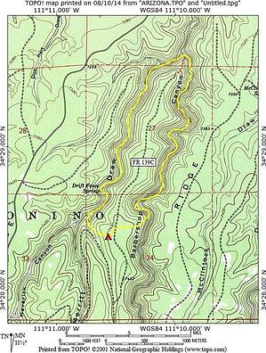
a charm of it's own by hikeaz  This short loop makes a decent introduction to off-trail hiking in this area. Most of the canyon bottoms in this area are similar in appearance, but each has its own charm. This short loop makes a decent introduction to off-trail hiking in this area. Most of the canyon bottoms in this area are similar in appearance, but each has its own charm.From our camp on 139C, we descended the western embankment down a gradual slope. Once in the Merritt creek-bottom, we turned downstream, sometimes hiking in the creek-bed and sometimes on the benches next to the creek. This is a beautiful, healthy forest rife with ferns and tall pines as well as some oaks.
Most continued up Barbershop Canyon passing a small but tall waterfall on creek-right (LDC) - It is a beautiful spring cascading down the rocks. As you continue, watch for a sharp left-hand bend in the creek-bed (see my map) at about 1.6/1.8 miles from the confluence. After rounding this bend, you will see on creek-left (LDC) a substantial elk trail heading upslope. It is a steep trail, but all-in-all not bad as these elk trails go. Once at the top, you will merely head west-ish across the flat pine-forest on a blanket of pine straw back to 139C and your starting point. If you choose to continue up Barbershop Canyon past where we exited, the canyon walls will get shallower, making a hike out less arduous, but we were shooting to exit close to our starting point. If YOU choose to continue further up Barbershop, exit where you please and road-walk back to your starting point. Hiking in these canyons does not require a GPS (pointless IN the canyon following the creek-bed), but a map does help. There are numerous elk trails offering ingress/egress, so just look for those; after all, these guys LIVE here and know the best routes. Check out the Official Route and Triplogs. Leave No Trace and +Add a Triplog after your hike to support this local community. | ||||||||||||||||||||||||||||||||||||||||||||||||||||||||||||||||||||||||||||||||||||||||||||||||||||||||