Route Editor

| Guide | ♦ | 4 Triplogs | 2 Topics |
details | drive | no permit | forecast | route |
stats |
photos | triplogs | topics | location |
| 103 | 4 | 2 |
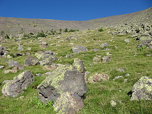
Highest Spring in Arizona! by Jim  The highest spring in Arizona couldn't have a nicer setting! Featured on the west side of the San Francisco Peaks, it has some of the finest views of any spring, and the alpine setting is unique for a "desert" state. Access is the main issue, but it is actually easy to find if you know where to look. Well, isn't that always the case! Don't use the USGS maps, as those currently have the spring one basin to the north, so you'll be lost if trying to find it. I recommend the existing HAZ data and my guide GPS route, which was never hiked and is only a guide. The highest spring in Arizona couldn't have a nicer setting! Featured on the west side of the San Francisco Peaks, it has some of the finest views of any spring, and the alpine setting is unique for a "desert" state. Access is the main issue, but it is actually easy to find if you know where to look. Well, isn't that always the case! Don't use the USGS maps, as those currently have the spring one basin to the north, so you'll be lost if trying to find it. I recommend the existing HAZ data and my guide GPS route, which was never hiked and is only a guide.This description leaves Arizona Snowbowl and uses the first few switchbacks of the Humphrey Summit Trail #151. After that point, it is all off-trail, and you will need good route finding skills and be comfortable on steep and rocky slopes. You will not approach the bomber wreck.
The next part is the most tricky because you want to hike almost parallel to the 9850' contour interval you happen to be near at the bottom of the Dutchman. This is because gaining too much will force you to descend a rocky avalanche slope that is tree-strewn, and it is completely unnecessary to subject yourself to that kind of route. On the other hand, losing elevation takes you downslope from where you want to be, and you might miss the Allison Clay Avalanche Chute. So, proceed across the forested slope and attempt to keep close to 9850', if you can. Once you reach the end of the forest, you should be looking into or down a short slope into the Allison Clay Avalanche Chute, which is one of many active chutes on the Peaks. Down trees are numerous here and mostly dated from a late 2008 slide. Hopefully, you should enter the slide low enough to look up most of it, and you can begin to hike up the rocky path. It's not as rough as the Dutchman, so don't worry. You will be in it for a while and will need to get close to the treeline on the slope that is to your north. Ultimately, you are trying to reach a point that allows you to enter the southwest and west-facing Bristlecone Pine forest, so you can once again traverse a slope to the next basin. You don't want to go high and cross over in the alpine tundra, as you will only increase the distance of the steep slope you will need to descend, and you will also unnecessarily rough up the fragile environment. If you have entered the open pine forest, start to go north to the basin where the spring is located. You can gain some elevation here, but try not to go too high. What you gain, you need to lose to access the spring's basin. You want to enter the basin low enough to view the alpine flowers in-season but high enough to avoid missing it or going through thorny shrubs. You will probably drop in from the pines, down a short slope, and see an iron pipe. If you do, this is good, as you can look up and see where you want to be. From any point in this avalanche chute, hike up near the pipe until you get to some man-made catchment structures. The actual spring is slightly uphill and to the northeast from these. If flowing, you can use the sound of the flowing water to locate it. I recommend locating Philomena when the water is flow, of course! Once at the spring, relax and enjoy. Officially, it would be best if you didn't go to the summit of Humphrey, as that is illegal. Well... be careful in the tundra and watch the plants! This hike is considered round-trip and as an out and back, so return from the spring to your vehicle the way you came. It is much easier returning! Being located so high and with little water retaining rock and earth above the spring, water availability is highly variable. Nearly dry or may be dry, in late spring to early summer before the rains come, overflowing in spring when the snow is melting above it, and again in the monsoon season when there have been abundant rains, Philomena Springs may be frozen from the middle of autumn to early winter before the snow covers the spring if it doesn't dry out entirely after the summer rains end. June is a nice time to visit, but don't expect water; consider yourself lucky if you get any. September, and during breaks in the monsoon surges, is the best time to visit. This is the San Francisco Peaks, so the wind is expected in spring, and therefore an otherwise nice day may not be so great if unlucky. Think of high winds in spring! Check out the Official Route and Triplogs. Leave No Trace and +Add a Triplog after your hike to support this local community. | ||||||||||||||||||||||||||||||||||||||||||||||||||||||||||||||||||||||||||||||||||||||||||||