username
X
password
register
for free!
help
  This is likely a great time to hike this trail!  Check out "Preferred" months below, keep in mind this is an estimate.
  

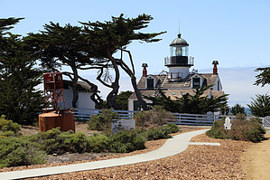
Point Pinos Lighthouse, CA

Guide 1 Triplog  0 Topics
  3 of 5  
Fav
Wish
0
details
drive
permit
forecast
map
stats
photos
triplog
topics
location
0 1 0
Statistics
tap row or icons for details
Difficulty 0.5 of 5
Distance Round Trip 0.67 miles
Trailhead Elevation 37 feet
Elevation Gain 25 feet
Accumulated Gain 35 feet
Kokopelli Seeds 0.85
 Interest Historic
 Dogs not allowed
feature photo
Photos Viewed All MineFollowing
151  2014-08-18
Big Sur Coastline - August 2014
Randal_Schulhaus
Author
author avatar Guides 16,843
Routes 17,472
Photos 24
Trips 1 map ( 6 miles )
Age 28 Male Gender
Location HAZ, TrailDEX
Associated Areas
list map done
Central Coast Region
Historical Weather
Trailhead Forecast
Expand Map
Preferred Aug, Sep, Jul, Oct
Sun  5:42am - 6:30pm
0 Route
 
0 Alternative


remove free decal offer

  Likely In-Season!
Guide Needed
Publish Full Detail Guide


Use +Add above to share photos and triplogs
Check out the oldest continuously operated lighthouse on the Pacific coast. Built in 1855 to guide sailors away from the rocky point approaching Monterey Bay. See www.pointpinos.org for more info...


    Check out the Triplog.
    Leave No Trace and +Add a Triplog after your hike to support this local community.
    WARNING! Hiking and outdoor related sports can be dangerous. Be responsible and prepare for the trip. Study the area you are entering and plan accordingly. Dress for the current and unexpected weather changes. Take plenty of water. Never go alone. Make an itinerary with your plan(s), route(s), destination(s) and expected return time. Give your itinerary to trusted family and/or friends.

     Permit $$
    Special Use


     Directions
    or
     Road
    Paved - Car Okay

    To hike
    page created by Randal_Schulhauser on Aug 19 2014 7:51 pm
     90+° 8am - 6pm kills
    helpcorrectionissue

    end of page marker