 Route Editor

| Guide | ♦ | 2 Triplogs | 0 Topics |
details | drive | no permit | forecast | 🔥 route |
stats |
photos | triplogs | topics | location |
| 0 | 2 | 0 |
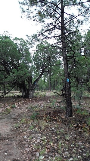
the jekyll and hyde trail by topohiker   GC Connector Trail GC Connector TrailThis trail connects the White Mountain trail system with the General Crook trail. It is the furthest west of the White Mountain trails. In order to connect to the General Crook trail, the Cottonwood trail is included in this description. The trail goes through the burned-out areas of the Rodeo-Chediski fire of 2002. The forest service put in some major trail maintenance and possible rerouting of these trails.
It is very hard to get lost on this trail. The trail is so well maintained, there are no obstacles on the trail. One good rule about this trail is if you have to cross over a log, you're off-trail! Every deadfall has been cleared from the trail. The FS even cut small 2-inch logs! The trail starts from the campground and heads through numerous canyons and burn areas. You slowly climb and come across the Left-Hand spring. Then you hike around and across the Left-Hand canyon. Then you’re in a pine forest. Along the way, you cross numerous roads and hike on abandoned roads. The General Crook Connector ends at FR132 (Pinedale Ridge RD). There is a sign for the General Crook Connector, but not the Cottonwood trail. Cottonwood Trail Once you cross the road, the trail slowly starts to change. There are only blue diamonds on the trees, then brown posts with diamonds, and finally only naked brown posts. The Cottonwood trail is well maintained just like General Crook Connector until Bald / Butler points. Also at this point the trail cuts across a canyon there are steep ups and downs with loose footing. Then the trail gets messy and the brown posts serve as ‘connector the trail’ points. Then you wound up hiking on a road with naked brown posts. The brown posts take you down into the Cottonwood wash. The topo maps show the trail turning to the south before the wash, but I didn't see any evidence of a trail. I think 1 of 2 things happens here: 1) The FS stopped the trail maintenance/reconstruction 2) The FS rerouted the trail down the Cottonwood Wash road I’m going with number 2 due to how the trail conditions went downhill and started following forest roads. Plus I saw one tree along the road with a blue diamond I believe the trail goes down the Cottonwood wash road to FR139. The General Crook Connector is a fun trail, while the Cottonwood is blah. There is not a lot of shade on these trails. So hiking in the cooler months would be best. Check out the Official Route and Triplogs. Leave No Trace and +Add a Triplog after your hike to support this local community. One-Way Notice This hike is listed as One-Way. When hiking several trails on a single "hike", log it with a generic name that describes the hike. Then link the trails traveled, check out the example. | ||||||||||||||||||||||||||||||||||||||||||||||||||||||||||||||||||||||||||||||||||||||||||||||||


