 Route Editor

| Guide | ♦ | 2 Triplogs | 0 Topics |
details | drive | permit | forecast | 🔥 route |
stats |
photos | triplogs | topics | location |
| 57 | 2 | 0 |
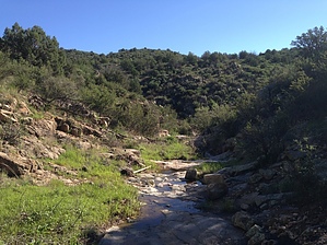
Board not Bored by kingsnake   Another hike starting from Glen Oaks -- a trailhead without fees or crowds. Another hike starting from Glen Oaks -- a trailhead without fees or crowds.Start off heading south along the jeep trail, which parallels Board Creek. At about a half-mile, Board Creek turns north into a small canyon; follow it. The creek bottom travel is very easy -- much, much easier than bushwhacking the very grab & grabby stabby local hillsides.
1.9 miles: You've reached Copper Creek. All that's left of the buildings on the topo is a foundation. Turn left/north up FR 54, which you will follow for the next ~4 miles. All of the other buildings on the topo, along the jeep trail, are now non-existent. For the most part, FR 54 is smooth walking, and probably drivable by a car -- if you could figure out how to get one down there. It's a slow, steady climb, past a couple of corrals, through a tunnel, up to FR 54's intersection with Copper Basin Rd. / FR 53. 6.0 miles: Turn left / southwest on FR 53. Initially, it is as nice as FR 54, climbing up to the hike's highpoint at about 6.8 miles. But, as FR 53 begins descending towards the multiply-signed mining claim, it will get rockier. 7.8 miles: Intersection, that if you turned right/west would proceed up to USMM 3275. (See "Glen Oaks - Peak 6276" hike description.) Continue on the main trail, FR 53, which will get rockier and definitely not car drivable. It's not bad, as far as rocky goes, but watch your footing anyway. Stay low on the jeep trail as it approaches Hwy 89, crossing through the second graffiti tunnel. Turn right/south a few hundred yards to the trailhead at Glen Oaks. 9.7 miles: Fini. Check out the Official Route and Triplogs. Leave No Trace and +Add a Triplog after your hike to support this local community. One-Way Notice This hike is listed as One-Way. When hiking several trails on a single "hike", log it with a generic name that describes the hike. Then link the trails traveled, check out the example. | |||||||||||||||||||||||||||||||||||||||||||||||||||||||||||||||||||||||||||||||||||||||||||


