Route Editor

| Guide | ♦ | 6 Triplogs | 1 Topic |
details | drive | permit | forecast | 🔥 route |
stats |
photos | triplogs | topic | location |
| 79 | 6 | 1 |
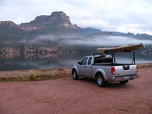
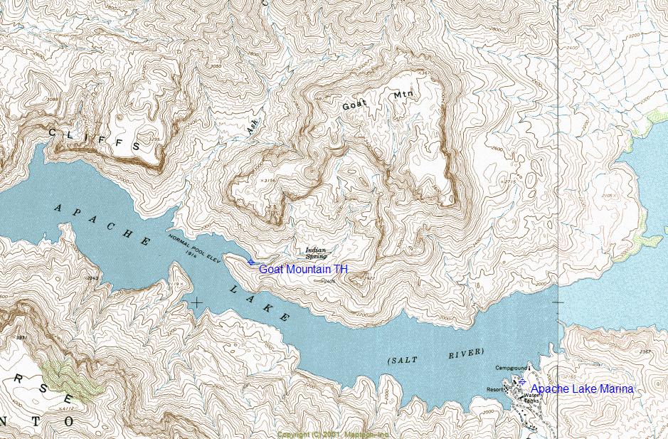
Surf & Turf I by ssk44  Goat Mountain is located within the Tonto National Forest along the north shore of Apache Lake. This hike is a fairly rugged yet manageable cross-country route with loose rubble rock. Access to this hike is via boat or, in my case, kayak. The trailhead is located at the first large cove on the north side of the lake, just 2.75 miles from the marina heading down towards the dam. The water level during the trip, as posted, was at 94% (1,908'). There is a large gravel bar at the back of the cove for tying up boats or for pulling kayaks out at this water level. This gravel bar would not be available at any level above 97%. Apache Lake is typically never kept above 95%. Goat Mountain is located within the Tonto National Forest along the north shore of Apache Lake. This hike is a fairly rugged yet manageable cross-country route with loose rubble rock. Access to this hike is via boat or, in my case, kayak. The trailhead is located at the first large cove on the north side of the lake, just 2.75 miles from the marina heading down towards the dam. The water level during the trip, as posted, was at 94% (1,908'). There is a large gravel bar at the back of the cove for tying up boats or for pulling kayaks out at this water level. This gravel bar would not be available at any level above 97%. Apache Lake is typically never kept above 95%.Goat Mountain is an extraordinary place that is loaded with character. The mountain has a horseshoe shape to it with ominous cliffs protecting the summit from most sides and has a hidden inner basin. This location offers lush desert vegetation, springs, waterfalls, rugged granite cliffs, solid granite buttes, an intriguing slot canyon, and a large elaborate cave at the base of the far butte on the southeast end of the main mountain. It's basically a hikers' playground with more places to explore than could ever be done in one trip. As posted, the hike primarily focuses on an inner basin tucked just below the summit. As seen on topo maps, the middle of the inner basin is an alluring secondary mountain about 200' above the drainages on both sides. This secondary mountain has a saddle at the middle point with a rugged rock ridgeline extending out both ends and has cliffs on each side.
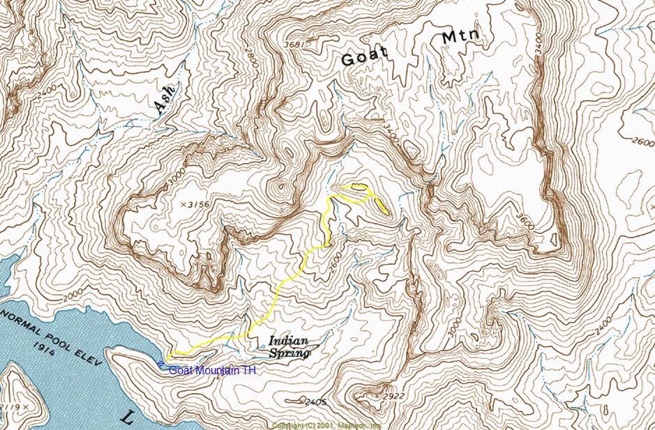
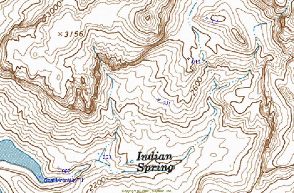
Although the hike obviously doesn't start until you reach the trailhead, the trip really begins at the marina. Apache Lake offers some of the best kayaking in the state. An early morning paddle to the trailhead will provide jaw-dropping silent beauty with the sun rising from the east behind you, shining brilliantly on the rugged terrain surrounding the lake. This lake is basically vacant until around 10:00 AM and particularly during the fall and winter seasons. After a 2.75-mile paddle from the marina, you will reach the trailhead. There are many ways to tackle this mountain. However, the route that I have posted is the least painful. From the beach, you will need to immediately climb up a short steep and loose section on the north side of the drainage to a flat area just above the lake (Mark 002, Lat. 33 degrees/35'/16.00"/N & Long. 111 degrees/17'/05.60" W). Hiking directly up the main drainage looked like a terrible bushwhack experience. Once on the flat area above the main drainage, you will be traveling northeast towards a small riparian area below a waterfall along a side canyon. You will be crossing the drainage above the waterfall (Mark 003 Lat. 33 degrees/35'/18.77"/N & Long. 111 degrees/16'/55.98"/W). If you try to hike up the bottom of the lower drainage to this waterfall, you will end up stuck in a solid stone water shute that did not look very manageable. From the waterfall, you will be following a series of ridges and shelves that work their way to the top with a mixture of granite boulders and lush vegetation ("Mark 007" Lat. 33 degrees/35'/29.62"/N & Long. 111 degrees/16'/41.77"/W). Just before reaching the inner basin, you will be climbing up and around a boulder outcropping with a deep canyon to your right ("Mark 011" Lat. 33 degrees/35'/37.81"/N & 111 degrees/16'/34.77"/W). Follow the remaining ridgeline north until the terrain levels off and cross a small water drainage coming from the basin's west side. You are now standing at the base of the secondary mountain positioned in the middle of the basin. The best place to climb this mountain is near the middle, where the rock outcroppings are not pronounced. On the western edge of this small mountain is a steep 125' +/- cliff ("Mark 014" Lat. 33 degrees/35'/45.81"/N & Long. 111 degrees/16'/30.44"/W). Following this route to the top will keep you out of about three steep and nasty canyons and prevent excessive bushwhacking. The route into the basin, as posted, is very manageable. However, the terrain in this area consists of loose rubble rock and demands respect. Caution There appeared to be a possible route to the summit following the right side of a steep rock canyon near the basin's western edge. Climbing out of the basin along this route is approximately 500' vertical of very steep and loose rubble rock. This route looked very sketchy to me and should only be attempted with EXTREME caution!!! Goat Mountain is an extraordinary place that begs to be explored. The hidden inner basin is best described as magical. The hike delivers from start to finish. This is a short hike into a beautiful and remote location that allows plenty of time to sit back and soak it all in. Kayaking to this location is a memorable trip in itself. Simply stunning beauty that won't soon be forgotten. Count on having it all to yourself if you go. Enjoy!
Check out the Official Route and Triplogs. Leave No Trace and +Add a Triplog after your hike to support this local community. | |||||||||||||||||||||||||||||||||||||||||||||||||||||||||||||||||||||||||||||||||||||||||||||||||||