Route Editor

| Guide | ♦ | 1 Triplog | 0 Topics |
details | drive | permit | forecast | 🔥 route |
stats |
photos | triplog | topics | location |
| 23 | 1 | 0 |
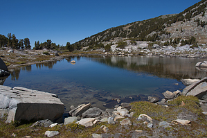
No deer, but worth it any/ by slegal The hike starts out at the Crystal Lake trailhead at Lake George. The trail switches back and forth as it overlooks Lake George.
As you head up a series of switchbacks, you'll get a few obscured views of Crystal Lake through the forest. Eventually, you'll reach a switchback with an unobstructed view of the Mammoth Lakes Basin. From here the tree cover thins and you travel up pumice switchbacks. You'll pass through a section of red cinders. Shortly after passing the cinders you'll reach a trail junction. Both trails meet back up. The left trail is shorter. After the two trails meet again you are on Mammoth Crest. Trail flattens out for a while allowing you some time to recover from the climb. This area is a treeless pumice field. Just ahead you can see the final climb before you reach Deer Lakes. The trail heads uphill through a whitebark pine forest. The Crest along this route rises from an elevation of about 10,600 feet to about 11,200 feet. This is not that steep a climb. After reaching the high point of the hike you will reach a chute overlooking the eastern part of the Mammoth Lakes Basin. Across the basin is a great view of Pyramid Peak. The cruel reality of the climb to the high point is that you have to go back down to 10,700 foot elevation to get to the Deer Lakes. Nevertheless, the lakes a worth the trip and the surrounding geology is stunning. We found a nice campsite to have lunch at that had a great view of two of the lakes. The cruel reality of the descent to the lakes is that the return ascent is very steep. It’s only about 500 vertical feet, but it is so steep that it is pretty tiring. Once you reach the high point, most of the return trip is downhill. Check out the Official Route and Triplog. Leave No Trace and +Add a Triplog after your hike to support this local community. | |||||||||||||||||||||||||||||||||||||||||||||||||||||||||||||||||||||||||||||||||||||||||||||||||||