 Route Editor

| Guide | ♦ | 21 Triplogs | 0 Topics |
details | drive | permit | forecast | route |
stats |
photos | triplogs | topics | location |
| 228 | 21 | 0 |
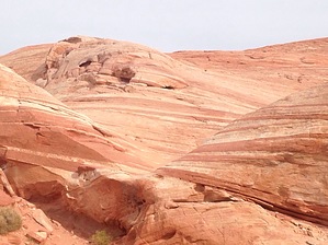
A short hike over sand and slickrock to a bowl-like formation made of alternating stripes of creamy-white and orange-red sandstone. Warning You are asked to stay on the trail to preserve the fragile nature of the formation and sparse vegetation.
The hike begins at Parking Area #3 off White Dome Road. Cross the road and pick up the trail heading east down a sandy slope. The trail leads you to the base of tall, dark red blocks of sandstone and then curves to the right. Headed now in a southerly direction you'll hike past the last of the blocks called Gibraltar Rock. From here you'll walk among some small boulders and up onto an expanse of slickrock. Follow the markers as much as possible (there aren't that many) and watch as the sandstone becomes more and more striped and wavy. About 1/2-mile in, the trail veers to the left. Continue to follow the markers to arrive at the Fire Wave. Retrace your steps to complete the hike. While not as tightly banded as Coyote Buttes North, the Fire Wave is definitely worth a visit. Keep in mind that the park is open from sunrise to sunset, so plan accordingly. Check out the Official Route and Triplogs. Leave No Trace and +Add a Triplog after your hike to support this local community. One-Way Notice This hike is listed as One-Way. When hiking several trails on a single "hike", log it with a generic name that describes the hike. Then link the trails traveled, check out the example. | |||||||||||||||||||||||||||||||||||||||||||||||||||||||||||||||||||||||||||||||||||||||||||||||||||||||||||||||||||||||||||||||||||||||||||||||||||||||||||||||||||||||||||||||||


