username
X
password
register
for free!
help
 This is likely a great time to hike this trail!  Check out "Preferred" months below, keep in mind this is an estimate.
  🔥

Mogollon Rim Viewpoints Loop - via 300D-300L, AZ

Guide 3 Triplogs  2 Topics
  3.7 of 5  
Fav
Wish
1
details
drive
no permit
forecast
🔥
route  
stats
photos
triplogs
topics
location
59 3 2
Statistics
tap row or icons for details
Difficulty 1.5 of 5
Route Finding 1 of 5
Distance Lasso-Loop 2.8 miles
Trailhead Elevation 7,570 feet
Elevation Gain 99 feet
Accumulated Gain 270 feet
Avg Time Round Trip 2 hours
Kokopelli Seeds 4.15
 Interest Off-Trail Hiking
unreported if dogs are allowed
editedit > ops > dogs to adjust
feature photo
Photos Viewed All MineFollowing
Will recalculate on button tap!
14  2020-10-05 Grasshopper
16  2015-06-29
Horton Creek Trail #285
FOTG
6  2015-05-24
Potato Lake - Mogollon Rim
Crzy4AZ
23  2014-09-25 Grasshopper
Author
author avatar Guides 16,843
Routes 17,472
Photos 24
Trips 1 map ( 6 miles )
Age 28 Male Gender
Location HAZ, TrailDEX
Associated Areas
list map done
Payson Region
Historical Weather
Trailhead Forecast
Radar Map
Expand Map
Preferred May, Sep, Oct, Jun
Sun  6:01am - 6:46pm
Official Route & 1 Rt
 
1 Alternative
 
Historic Fire Perimetersacres
🔥 2017 Bear Fire11
🔥 2009 Rim Fire2.5k
🔥 1990 Dude Fire21.4k
🔥 View (All) - over Official Route 🔥


remove free decal offer

 Likely In-Season!
Guide Needed
Publish Full Detail Guide


Use +Add above to share photos and triplogs
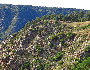
A short, scenic, and partial off-trail lollypop loop hike to seven high elevation viewpoints from our Mogollon Rim.

Happy

Trails!


    Check out the Official Route and Triplogs.
    Leave No Trace and +Add a Triplog after your hike to support this local community.
    WARNING! Hiking and outdoor related sports can be dangerous. Be responsible and prepare for the trip. Study the area you are entering and plan accordingly. Dress for the current and unexpected weather changes. Take plenty of water. Never go alone. Make an itinerary with your plan(s), route(s), destination(s) and expected return time. Give your itinerary to trusted family and/or friends.

     Permit $$
    None


     Directions
    or
     Road


    To hike
    From the Phoenix area: Drive Hwy 87 north through Payson, Pine, and Strawberry.. approx 10.5 miles north of Strawberry on Hwy 87 at MP281.1, turn right at signed FR300 (the Rim Road) and continue on FR300 for ~13.2 miles to the intersection with easy to miss but signed FR398. Turn left onto FR398 and continue for ~.30 miles to road "right side" Parking for Camp Grasshopper C/Site#4 (at waypoint 34.44423 -111.23421). There is also parking for ~2 vehicles approx 200ft further on FR398 on left side. Please Note: It is highly recommended that you download and follow the Driving Route (with key waypoints) posted above to this hike description.
    page created by Grasshopper on Oct 12 2014 12:01 pm
     90+° 8am - 6pm kills
    helpcorrectionissue

    end of page marker