This hike starts unlike most. A half-mile trip across Bartlett Lake by boat, kayak, float, or swim is required to get to where Canyon Creek drains into the lake. As you make your way up Canyon Creek, you pass through pockets of riparian habitat and nice little sections of perennial creek. Water flow is dependent on received moisture in the area.
It's about a mile of easy rock hopping to reach SB Cabin. The cabin itself is in good shape and features some rusting spring bed frames and tables with remnants of past visitors. Some may choose to make this destination a kicker to a day on the lake, while others choose to tackle SB mountain in the distance.
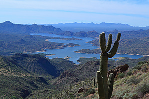
A little over a quarter-mile further up the creek a drainage flows in from the right. This offers a good opportunity to begin your approach up the mountain. I found it was easier to leave the drainage and make way up the bajada. Since it's all off-trail, put your route-finding skills to use and do as you wish to ascend the mountain. Vegetated scree and rock faces can make the climb slow going. As with any mountain climb, the higher you go the greater the views. The final 100 or so feet to the summit become slightly challenging. The rock outcropping that makes up the summit is steep and composed of loose rocks. Once on top, you are rewarded with great views looking up into the Mazatzals and out over Bartlett Lake. Because of the lake, visitors are not frequent and you are sure to have this area to yourself.
WARNING! Hiking and outdoor related sports can be dangerous. Be responsible and prepare for the trip. Study the area you are entering and plan accordingly. Dress for the current and unexpected weather changes. Take plenty of water. Never go alone. Make an itinerary with your plan(s), route(s), destination(s) and expected return time. Give your itinerary to trusted family and/or friends.
Permit $$
None
Directions
Road
Paved - Car Okay
To hike Drive to Bartlett lake. Take N Bartlett Lake rd north. Turn left at the stop sign. Continue to the end of the road. park and unload your vessel. No Tonto pass is required for this area.
 Route Editor

 This hike starts unlike most. A half-mile trip across Bartlett Lake by boat, kayak, float, or swim is required to get to where Canyon Creek drains into the lake. As you make your way up Canyon Creek, you pass through pockets of riparian habitat and nice little sections of perennial creek. Water flow is dependent on received moisture in the area.