Reverse Flatiron is a very steep, scrambly, and off-trail route that begins near the Massacre Falls hike and climbs steadily up to peak 5024 before dropping down to the Flatiron. This route is only recommended for the most adventurous and experienced off-trail hikers.
Page statistics are for the popular loop. You could hike as an out-n-back. Generally, by the time you get to the Flatiron, it seems like a much more comfortable hike down to Flatiron and back around Jacob's Crosscut on maintained trails.
Look under the "Alternative Routes" tab for variations others have taken. You might consider the First Water Tributaries if you want to start at the First Water Trailhead. This is also a nice free alternative for a meatier version of the Superstition Ridgeline.
Joe Bartels created the term "Reverse Flatiron" in 2007 when the now non-existent Massacre Trailhead existed. Now the Crosscut Trailhead is the nearest trailhead to conquer the Flatiron in the reverse fashion.
When hiking several trails on a single "hike", log it with a generic name that describes the hike. Then link the trails traveled, check out the example.
WARNING! Hiking and outdoor related sports can be dangerous. Be responsible and prepare for the trip. Study the area you are entering and plan accordingly. Dress for the current and unexpected weather changes. Take plenty of water. Never go alone. Make an itinerary with your plan(s), route(s), destination(s) and expected return time. Give your itinerary to trusted family and/or friends.
Permit $$
no fees or permits reported
if incorrect tell us about it
Directions
Road
Paved - Car Okay
To Crosscut Trailhead From Mesa:
Follow US 60 east to Idaho Road. Turn North onto Idaho Road which is SR88 and follow it North 2.2 miles. SR88 bends right just past Scenic St. and Idaho continues North. Be sure to go right and stay on SR88. Follow SR88 5.2 miles to the signed turnoff for First Water Trailhead(large brown sign), this is FR78. Turn right onto FR78 and follow 0.6 miles to the large dirt parking lot which is the Crosscut Trailhead.
FR 78 is graded and passable for most low-clearance 2WD cars, but could be difficult after heavy summer rains. This trailhead is the traditional one for trail #58 and is frequently used as the fee-free alternative to hike the Flatiron and such.
From US 60 West: (Gold Canyon, Superior, etc)
Take Mountain View Rd north instead of Idaho Rd to save 5-6 miles. The turn for Mountain View Rd comes quickly after Silly Mountain. Turn right onto SR88.
Tip:
The crucial right turn onto FR78, is exactly 1 mile after the turn to Lost Dutchman.
From PHX (I-10 & AZ-51) 41.1 mi - about 52 mins From TUC (Jct 1-10 & Grant) 134 mi - about 2 hours 9 mins From FLG (Jct I-17 & I-40) 185 mi - about 2 hours 56 mins
 Route Editor

 Reverse Flatiron is a very steep, scrambly, and off-trail route that begins near the Massacre Falls hike and climbs steadily up to peak 5024 before dropping down to the Flatiron. This route is only recommended for the most adventurous and experienced off-trail hikers.
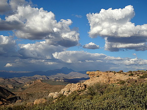


