username
X
password
register
for free!
help


Margies Peak - Skull 2493, AZ

Guide 17 Triplogs  1 Topic
  3.7 of 5  
Fav
Wish
1
details
drive
no permit
forecast
route  
stats
photos
triplogs
topic
location
279 17 1
Statistics
tap row or icons for details
Difficulty 3.5 of 5
Distance Loop 3.3 miles
Trailhead Elevation 1,112 feet
Elevation Gain 1,378 feet
Accumulated Gain 1,450 feet
Kokopelli Seeds 10.55
 Interest Off-Trail Hiking & Peak
feature photo
Photos Viewed All MineFollowing
Inaugural Calculation on Button Tap!
52  2023-12-05 Mike_W
26  2022-02-22
Margies Oatman
DixieFlyer
5  2018-10-02 chumley
3  2016-10-27 mt98dew
58  2015-01-01
4th Annual New Year's Day Peak Celebration
Nightstalker
18  2015-01-01
4th Annual New Year's Day Peak Celebration
Grimey
21  2015-01-01
4th Annual New Year's Day Peak Celebration
outdoor_lover
14  2015-01-01
4th Annual New Year's Day Peak Celebration
Oregon_Hiker
Page 1,  2
Author
author avatar Guides 16,843
Routes 17,472
Photos 24
Trips 1 map ( 6 miles )
Age 28 Male Gender
Location HAZ, TrailDEX
Associated Areas
list map done
Phoenix Region
Historical Weather
Trailhead Forecast
Radar Map
Expand Map
Preferred Dec, Jan, Feb, Nov
Sun  6:07am - 6:50pm
Official Route & 3 Rts
 
1 Alternative


remove free decal offer

 
Guide Needed
Publish Full Detail Guide


Use +Add above to share photos and triplogs


Happy

Trails!


    Check out the Official Route and Triplogs.
    Leave No Trace and +Add a Triplog after your hike to support this local community.
    WARNING! Hiking and outdoor related sports can be dangerous. Be responsible and prepare for the trip. Study the area you are entering and plan accordingly. Dress for the current and unexpected weather changes. Take plenty of water. Never go alone. Make an itinerary with your plan(s), route(s), destination(s) and expected return time. Give your itinerary to trusted family and/or friends.

     Permit $$
    None


     Directions
    or
     Road
    FR / Jeep Road - Car possible when dry

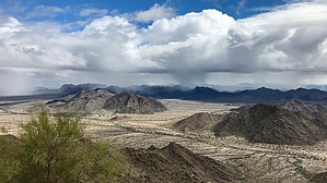
    To hike
    From Phoenix, take I-10 West and exit onto State Highway 85. Proceed on State Highway 85 past the Buckeye Hills Recreation Area and the State Prison to MP 134 at Woods Road. Turn Left (East) on Woods Road which will turn into a Dirt Road right away. After Crossing the Cattle Guard, take an immediate Left, even though it appears that there is no Road there. It's there, and it basically does a U-Turn and follows the other side of the Fenceline back to the West, before turning North. At 3.4 Miles from the Cattle Guard, you will start to cross a Large Wash. The Sand is hard packed here and you can park in the Wash. If you are not comfortable with that, proceed another 0.8 Miles to the Turnoff for the Margies Cove Trail TH and Park there. The Road has some Sandy Spots, but the Sand is not Deep. A Low Clearance Car may have some Trouble in a few Washed out areas, especially at the Wash Crossings, but an SUV or Truck is fine.
    page created by outdoor_lover on Nov 11 2014 3:58 pm
     90+° 8am - 6pm kills
    helpcorrectionissue

    end of page marker