username
X
password
register
for free!
help
 

White Rock 3012 - Telegraph Canyon, AZ

Guide 1 Triplog  0 Topics
  0 of 5  
Fav
Wish
1
details
drive
no permit
forecast
map
stats
photos
triplog
topics
location
43 1 0
Statistics
tap row or icons for details
Difficulty 1.5 of 5
Distance One Way 2 miles
Trailhead Elevation 2,636 feet
Elevation Gain 376 feet
Accumulated Gain 550 feet
Kokopelli Seeds 3.83
 Interest Off-Trail Hiking
unreported if dogs are allowed
editedit > ops > dogs to adjust
feature photo
Photos Viewed All MineFollowing
43  2014-12-01 kingsnake
Author
author avatar Guides 16,843
Routes 17,472
Photos 24
Trips 1 map ( 6 miles )
Age 28 Male Gender
Location HAZ, TrailDEX
Associated Areas
list map done
Globe Region
Historical Weather
Trailhead Forecast
Expand Map
Preferred Mar, Nov, Feb, Jan
Sun  6:02am - 6:43pm
1 Route
 
0 Alternative


remove free decal offer

Guide Needed
Publish Full Detail Guide


Use +Add above to share photos and triplogs
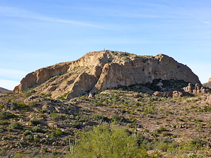
White Rock x3012 is a large, white, rock just south of Telegraph Canyon. It has sheer 80-100 foot walls on all sides. Though a strong climber may be able to scramble to the top -- then write a complete hike description, including how they did so -- I was not able to find an easy route.


    Check out the Triplog.
    Leave No Trace and +Add a Triplog after your hike to support this local community.

    One-Way Notice
    This hike is listed as One-Way.

    When hiking several trails on a single "hike", log it with a generic name that describes the hike. Then link the trails traveled, check out the example.
    WARNING! Hiking and outdoor related sports can be dangerous. Be responsible and prepare for the trip. Study the area you are entering and plan accordingly. Dress for the current and unexpected weather changes. Take plenty of water. Never go alone. Make an itinerary with your plan(s), route(s), destination(s) and expected return time. Give your itinerary to trusted family and/or friends.

     Permit $$
    None


     Directions
    or
     Road
    FR / Jeep Road - Car possible when dry

    To hike
    This is the same trailhead as for Hill 3464: From Phoenix, as you head east on U.S. 60, take the first paved road south (Mary Dr.). The road bends left, then right, around a housing area. At .5 miles, it bends left at the fire station. At the fire station intersection, turn right onto Telegraph Canyon Rd. At 1.0 miles, it turns from pavement to gravel. There are many side trails, stay on the main / largest one (Telegraph Rd.). At 1.9 miles, the road turns west, and starts getting worse. You will reach the designated trailhead at 2.2 miles. Do not even think of trying to drive past the designated TH without high clearance, 4x4 and some skill.
    page created by kingsnake on Dec 02 2014 1:53 pm
     90+° 8am - 6pm kills
    helpcorrectionissue

    end of page marker