Route Editor

| Guide | ♦ | 25 Triplogs | 1 Topic |
details | drive | permit | forecast | 🔥 route |
stats |
photos | triplogs | topic | location |
| 254 | 25 | 1 |
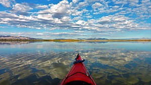
Whatever floats your boat! by azbackpackr  This wildlife refuge offers opportunities for kayaking Topock Marsh, Topock Gorge, and the upper end (north end) of Lake Havasu. Mountain biking is possible on the portage roads. It's a prime area for birders since it is part of the migratory bird flyway and is a year-round home for many water birds. There is hiking in the refuge's wilderness area as well, but there are no established trails. This wildlife refuge offers opportunities for kayaking Topock Marsh, Topock Gorge, and the upper end (north end) of Lake Havasu. Mountain biking is possible on the portage roads. It's a prime area for birders since it is part of the migratory bird flyway and is a year-round home for many water birds. There is hiking in the refuge's wilderness area as well, but there are no established trails.The most popular route for kayakers is Topock Gorge, a spectacular section of the Colorado River between the Interstate 40 bridge and Lake Havasu. For beginning kayakers and bird watchers, Topock Marsh is the place to go.
Mountain bikers need to stay on the levee roads. No camping is permitted ANYWHERE on the refuge. No overnight backpacking, no overnight kayaking, no car camping, no RV camping, etc. Several Kayak shuttle services are available in the area. Companies such as Desert River Kayak Outfitters and Jerkwater Canoe Company will provide this service and rental boats. Due to the strong river current, a shuttle is necessary to do Topock Gorge. A shuttle is not required to kayak in the calm waters of Topock Marsh. A couple of good maps are available. One excellent map, "Lake Havasu", is published by Fish N Map Company. Another pretty good one can be downloaded and printed for free from this website: [ 2021 deadline removed, view archived on HAZ ] These maps both also include river and lake sections between Davis Dam (Bullhead City, Arizona) and Parker Dam (Lake Havasu). NO FEES are charged to enter the refuge. Reference
Check out the Official Route and Triplogs. Leave No Trace and +Add a Triplog after your kayak trip to support this local community. | |||||||||||||||||||||||||||||||||||||||||||||||||||||||||||||||||||||||||||||||||||||||||||||||||||||||||||||||||||||||||||||||||||||||||||||||||||||||||||||||||||||||||||||||||||||||