Route Editor

| Guide | ♦ | 4 Triplogs | 0 Topics |
details | drive | no permit | forecast | route |
stats |
photos | triplogs | topics | location |
| 52 | 4 | 0 |
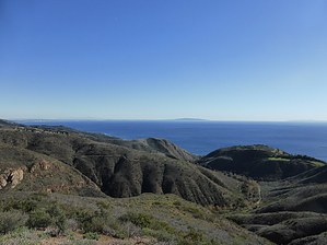
A Lush Riparian Canyon in the Santa Monicas by winotron  This hike is a 3.2 mile loop combining the the Rising Sun Trail and the Solstice Canyon Trail. I will describe this hike going CCW starting with the Rising Sun Trail. The perennial creek flows all the way to the trailhead, and it's a great way to start your hike. From the north side of the parking lot head up the set of stairs on your right to get on the Rising Sun Trail. You'll start getting some nice views of the Pacific Ocean right away as you climb. You'll get almost all of your AEG on this trail, but it's nothing too steep. The whole Rising Sun Trail is also very exposed, with little to no shade. The trail is well-maintained and easy to follow. You'll slowly ascend the east side of the canyon, checking out all the crazy mansions up in the hills.
The creek runs right next to the ruins, and you'll see a sign directing you just upstream to the waterfall. The Roberts family had a view of this waterfall right out their back window. The small, cascading waterfall is maybe 25 ft tall, with a small pool at the bottom. It's a very nice, serene area. When you've had your fill of the waterfall, head to the west side of the ruins and take the mostly-paved Solstice Canyon, which is really a wide fire road, back to the trailhead. It's just over a mile back to the trailhead, and is very pleasant and shaded most of the way. You parallel the creek to your left the whole way, and it's lined with huge old oaks and sycamores. Most people just hike this trail up to the ruins and back, which is about 2.5 miles round trip and 400 AEG. There are a few interpretive signs along the way that give you some history of the area, and there are some ruins of another small stone house that burned down in 2007 that you can check out. You'll be back to the parking lot before you know it. If you want those spectacular ocean views, you can extend your hike in a couple ways. Immediately when you start heading back from the ruins on the Solstice Canyon Trail you'll see a sign for the Sostomo Trail on your right. This trail will immediately take you up and out of the west side of the canyon, then down to a creek crossing and back up again. It's fairly steep and a heck of a workout... you'll climb about 1000 ft in just over a mile. You'll meet a junction with the Deer Valley Loop Trail, which is another optional 1.3 mile loop that will just bring you back to this point. The signs here are a bit confusing, but no matter which way you go you'll end up back at this spot. Watch out for signs marking private property. Keep heading south on Sostomo to an absolutely breathtaking panoramic ocean view. From here you can keep following Sostomo and loop back around on Deer Valley, or just return the way you came. On our trip we did the entire loop and our hike came to about 7.5 miles and 2000 AEG. Check out the Official Route and Triplogs. Leave No Trace and +Add a Triplog after your hike to support this local community. | ||||||||||||||||||||||||||||||||||||||||||||||||||||||||||||||||||||||||||||||||||||||||