 Route Editor

| Guide | ♦ | 41 Triplogs | 0 Topics |
details | drive | no permit | forecast | route |
stats |
photos | triplogs | topics | location |
| 387 | 41 | 0 |
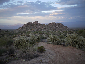
Photogenic granite outcrop by Crzy4AZ  This trail segment is split between the McDowell Sonoran Preserve (0.5 miles) and the McDowell Mountain Regional Park (0.6 miles) and is a picturesque short trail that allows scenic loops between the two multi-use areas. This trail segment is split between the McDowell Sonoran Preserve (0.5 miles) and the McDowell Mountain Regional Park (0.6 miles) and is a picturesque short trail that allows scenic loops between the two multi-use areas.The GPS route and this description will start from the closest access point in the MSP (McDowell Sonoran Preserve). From Tom's Thumb Trailhead (23015 N 128th Street) where there is equestrian parking and regular parking but no water, you take Marcus Landslide Trail 0.4 miles to junction with Rock Knob trail.
At 0.3 miles you will see ranching artifacts under an old mesquite tree. You cross into the McDowell Mountain Regional Park (MMRP) at 0.5 miles and there are paths for approved rock climbing routes. In some older rock climbing documents and books, the Rock Knob area is referred to as "Knob Hill" but the adopted MSP Rock Climbing Plan in 2011 made the official name change to Rock Knob. If you want to read the official rock climbing guidelines for the MSP approved in 2011 - read here. Continue on Rock Knob trail within MMRP to the intersection with Pemberton Trail. You can connect to the backside of Windgate Pass by taking Pemberton to Coachwhip to Windmill Trail. Or you could take Pemberton Trail to Boulder Trail and make a little loop to Marcus Landslide trail. Many great options by foot, bike, or horse in this area.
Check out the Official Route and Triplogs. Leave No Trace and +Add a Triplog after your hike to support this local community. One-Way Notice This hike is listed as One-Way. When hiking several trails on a single "hike", log it with a generic name that describes the hike. Then link the trails traveled, check out the example. | ||||||||||||||||||||||||||||||||||||||||||||||||||||||||||||||||||||||||||||||||||||||||||||||||||||||||||||||||||||||||||||||||||||||||||||||||||||||||||||||||||||||||||||||||||||||


