|
Apache Vista Trail - Sonoran Pres...
|
2.83 mi
385 ft |
 |
|
Ocotillo Ridgeback Sidewinder Loop
|
4.45 mi
496 ft |
|
|
Apache Wash
|
7.27 mi
935 ft |
|
|
Ocotillo - Ridgeback - Sidewinder
|
4.55 mi
561 ft |
|
| Apache - Sidewinder - Badger
|
4.21 mi
240 ft |
|
|
|
Phx Sonoran Preserve N
|
1.94 mi
91 ft |
|
| Sidewinder Ridgeback Ocotillo Loop
|
6.18 mi
851 ft |
|
|
| Apache Wash - Esplanade Loop
|
11.05 mi
447 ft |
|
|
|
And it begins
|
9.98 mi
1,264 ft |
|
|
Esplanade Owl Check Up
|
5.13 mi
161 ft |
|
|
Esplanade Owl Check Up - Apache T...
|
8.47 mi
433 ft |
|
|
Esplanade Owl Check - Apache Wash...
|
7.75 mi
215 ft |
|
|
Sidewinder via Apache Vista
|
5.36 mi
517 ft |
|
|
Apache Wash
|
5.84 mi
810 ft |
|
|
Apache Vista twice - Sidewinder -...
|
7.86 mi
1,067 ft |
|
|
Apache Wash - Sidewinder - Double...
|
6.75 mi
624 ft |
|
|
Sidewinder and Apache Vista
|
5.36 mi
507 ft |
|
|
Apache Wash
|
11.71 mi
1,060 ft |
|
|
Esplanade Owl Search
|
5.2 mi
158 ft |
|
|
Apache Wash - Sidewinder - Ridgeback
|
8.02 mi
692 ft |
|
|
Ridgeback Peak and Loop
|
4.55 mi
585 ft |
|
|
Sidewinder with double Apache Vista
|
3.88 mi
460 ft |
|
|
Southern Apache Wash Loop and Peak
|
4.89 mi
418 ft |
|
|
Apache Vista Double and Apache Wa...
|
9.93 mi
785 ft |
|
|
Phoenix Sonoran Preserve N - East...
|
8 mi
282 ft |
|
|
Esplanade Trail Owl Checkup
|
5.15 mi
193 ft |
|
|
Esplanade and Apache Vista
|
7.88 mi
492 ft |
|
|
Esplanade and Apache Vista
|
7.8 mi
631 ft |
|
|
Esplanade Owl Search
|
5.33 mi
164 ft |
|
|
Badger Cliff Esplanade
|
7.27 mi
359 ft |
|
|
O R S A - Sonoran Preserve North
|
4.48 mi
550 ft |
|
| Ocotillo Trail - Sonoran Preserve...
|
4.21 mi
597 ft |
|
|
| Sidewinder Trail - Sonoran Perser...
|
2.77 mi
319 ft |
|
|
| Cliff Walk Trail - Sonoran Preser...
|
11.58 mi
601 ft |
|
|
| Ocotillo Trail - Sonoran Preserve...
|
13.63 mi
1,471 ft |
|
|
| Cliff Walk Trail -Esplanade Trail...
|
9.47 mi
338 ft |
|
|
| Apache Wash TH Sonoran Preserve
|
12.58 mi
494 ft |
|
|
| Sonoran Preserve North Sampler
|
12.53 mi
1,073 ft |
|
|
| Apache Wash Loops
|
5.7 mi
480 ft |
|
|
| Sidewinder-Apache Wash Loop
|
4.66 mi
299 ft |
|
|
| Cliff Walk- Esplanade Trail Loop
|
9.58 mi
345 ft |
|
|
| Apache Wash Connector Loop
|
6.06 mi
189 ft |
|
|
| Badger Brawl Trail - Sonoran Pres...
|
8.01 mi
253 ft |
|
|
| Sidewinder / Apache Wash
|
2.07 mi
155 ft |
|
|
 Route Editor


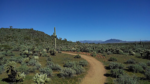
 This is a new trail in the Sonoran Preserve North. This trail includes the old Apache Wash, which was really a short connector to Sidewinder and Ocotillo Trails. But now the trail is a nice loop that is just under seven miles. The hike itself is easy and is well defined.