 Route Editor

| Guide | ♦ | 7 Triplogs | 0 Topics |
details | drive | permit | forecast | route |
stats |
photos | triplogs | topics | location |
| 12 | 7 | 0 |
Heart of the Muir Woods by hippiepunkpirate  Muir Woods National Monument preserves one of last pristine stands of Coastal Redwood forest remaining along the Northern California Coast. The Monument itself was created in 1908 when the property was donated to the federal government by U.S. Congressman William Kent in order to prevent development of this special place. When declaring the Monument, President Theodore Roosevelt wanted to name it after William Kent. However, Kent insisted the park bear the name of famous American naturalist John Muir. Trail
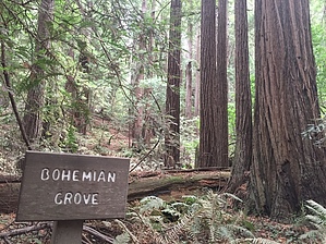
The trail is officially a 2 mile multi-loop, with the different legs separated by Redwood Creek and connected by a series of wooden footbridges that span the creek. Copious interpretive signage is provided along the trail, explaining about the unique ecosystem of the Coastal Redwood forest. A "self-guided" tour is available at the Visitor Center by purchasing a pamphlet for $1 and following along on the numbered signs along the trail. Along the trail, adjacent to the Gifford Pinchot tree (one of the largest Redwoods in the park), is an open area where park rangers can often be found giving talks for visitors. The two most impressive Redwood stands are the Bohemian Grove and the Cathedral Grove, both of which are well marked on trailside maps. Connection Options: While a simple walk on the Main Trail is likely perfect for most park visitors (aka: non-hikers), an avid hiker visiting the park will likely have a thirst for MORE. The most popular extension off the Main Trail is to make the loop hike a hair more interesting a difficult with no extra distance by adding a jaunt on the Hillside Trail, a pleasant dirt footpath that parallels the main boardwalk a little ways up on the nearby slopes. Longer loops or out and back hikes can be achieved of almost any desired distance. The Dispea, Ocean View, Fern Creek, and Camp Eastwood Trails all split off from the Main Trail and connect with trails within the nearby Mount Tamalpais State Park. These spur trails also run through some nice stretches of Redwoods (giant Coastal Douglas Fir can also be found nearby). The Main Trail is of course the must do part of the park, but a fit hiker could be out in the Muir Woods all day exploring miles of pristine Pacific Coast trails. Crowd Control: Muir Woods National Monument is one of the top tourism attractions in the San Francisco Bay Area, as well as being a convenient local escape for city dwellers. Parking lots fill up early on sunny days, but overlow parking is available along the Muir Woods Road downhill from the park entrance. However, arriving mid-day on a busy day may result in a complete parking nightmare. It's recommended to go early (arriving 9am or earlier), or late (two hours before sundown) if parking may be a concern. Muir Woods NM closes at sundown every day. Check out the Official Route and Triplogs. Leave No Trace and +Add a Triplog after your hike to support this local community. One-Way Notice This hike is listed as One-Way. When hiking several trails on a single "hike", log it with a generic name that describes the hike. Then link the trails traveled, check out the example. | ||||||||||||||||||||||||||||||||||||||||||||||||||||||||||||||||||||||||||||||||||||||||||||||||


