Route Editor

| Guide | ♦ | 4 Triplogs | 1 Topic |
details | drive | permit | forecast | map |
stats |
photos | triplogs | topic | location |
| 51 | 4 | 1 |
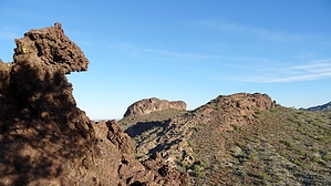
Questing for a Cuesta Fiesta? by Barrett  If you're looking for wild geology untrammeled by crowds, loaded with alcoves, arches, and even a few tunnels and caves, you probably wouldn't think to look in the White Tank Mountains. That's what I thought until a Google Earth image lured me to venture behind the range, where a group of small formations that looked pretty bland from a distance revealed dizzying complexity up close. If you're looking for wild geology untrammeled by crowds, loaded with alcoves, arches, and even a few tunnels and caves, you probably wouldn't think to look in the White Tank Mountains. That's what I thought until a Google Earth image lured me to venture behind the range, where a group of small formations that looked pretty bland from a distance revealed dizzying complexity up close.Geologically, they are "cuestas," asymmetrical ridges with a gentle back slope (called a Dipslope), and a steep face or cliff formed by the erosion of tilted strata with a resistant capstone. The freeze-thaw cycle and other breakdown types often form alcoves in the cliff face, and here is no exception. The rock itself, ejected from a volcanic eruption somewhere between 5 and 33 million years ago, it's twisted molten form taking on fantastic shapes that make for a scramblers delight.
The 5 significant points of interest: 1982' - Most dramatic summit, largest cliff faces, 30' tunnel, 4 large alcoves - including the "Weeping Alcove," that due to a fissure in the cuesta above shows evidence of water flow over a significant period of time. Most features on north and east faces. "Two - Tone" - 4 large alcoves ( 1 unexplored - rope protection suggested), 6 medium alcoves, 12 small, 6 small arches, 1 60' tunnel connecting the top of the cuesta with it's base. Most features on north, east, and south faces. 1861' - 6 medium alcoves, 12 small alcoves, 12 small arches. Features on all faces. Baldy" - 1 medium alcove, 4 small alcoves. Features on south ridge. 1908' - 12 medium alcoves, 6 small arches, most intense molten forms. Features along ridge, as well as entire east face. Flora is light, with a few areas of Cholla but very little catclaw. In most areas, the rock is incredibly grippy and solid, but a few spots, particularly on 1982', are crumbly, so stay on your toes. As with any off-trail hike in terrain as unpredictable as this, exercise caution and stay within your comfort level. The "Red Road" divides Buckeye from Phoenix, and the area is a combination of State Trust and BLM land, all of it outside the White Tank Mountain Park boundaries. Technically a State Trust permit would be handy, but I have seen no posting warning of this requirement. In 4 trips to the area, I have only seen one other person and almost no trash. I hope to return with some HAZheads who want to further explore the alcoves and caves that were beyond my solo comfort level (a rope wouldn't hurt) - you never know what might be found until you look! Check out the Triplogs. Leave No Trace and +Add a Triplog after your hike to support this local community. | ||||||||||||||||||||||||||||||||||||||||||||||||||||||||||||||||||||||||||||||||