 Route Editor

| Guide | ♦ | 111 Triplogs | 2 Topics |
details | drive | no permit | forecast | route |
stats |
photos | triplogs | topics | location |
| 1.6k | 111 | 2 |
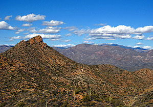
  Overview OverviewFrom the Freeman Road Trailhead, the route follows sinuous singletrack and occasional doubletrack roads through a remote corner of Arizona. It goes under some high-tension powerlines, crosses two two-track roads, and then crosses a gas line road. It then turns to the west, crosses a large wash, and begins following a fenceline. After going through a gate the trail turns to the northwest and passes by a large pile of erratic granite boulders. From here the trail continues through the desert, crossing several washes, another road, and a gate, just above Tecolote Ranch Road. After crossing this road the trail keeps to the north, crosses under powerlines, and joins a road. It follows this road for almost 2 miles and then heads overland before joining another road. From here the trail turns north, passes several road junctions, and climbs to a gate on a hill. The trail descends the northeast side of this hill and then follows a drainage to a road. After leaving the road the trail descends to Ripsey Wash, follows it for a ways, and then turns into a side canyon and begins climbing up the Big Hill. After switchbacking around the hill the trail heads north-northwest along a ridgeline. It turns to the east and then back due north, and then starts a long descent. After crossing several washes the trail reaches the Florence-Kelvin Trailhead. It crosses the highway and heads in a north-northeast direction. After crossing a large wash it curves around and down to the Kelvin Bridge and the Gila River. Southern Trailhead: Freeman Road
Updated 2021-09-30 Gate Policy: If a gate is closed upon arrival, leave it closed after you go through. If it is open, leave it open. Leaving a closed gate open may put cattle in danger. Closing an open gate may cut them off from water. Please be respectful, leave gates as found. The exception is signage on the gate directing you otherwise. Check out the Official Route and Triplogs. Leave No Trace and +Add a Triplog after your hike to support this local community. One-Way Notice This hike is listed as One-Way. When hiking several trails on a single "hike", log it with a generic name that describes the hike. Then link the trails traveled, check out the example. | ||||||||||||||||||||||||||||||||||||||||||||||||||||||||||||||||||||||||||||||||||||||||||||||||||||||||||||||||||||||||||||||||||||||||||||||||||||||||||||||||||||||||||


