The canyon east of Hieroglyphic Canyon within the Western Superstition Wilderness. This less visited canyon hike is scenic, rugged and mostly off-trail.
This unofficial hike is arbitrary. Don't rush it. Explore a little. For you are today's Tom Sawyer.
When hiking several trails on a single "hike", log it with a generic name that describes the hike. Then link the trails traveled, check out the example.
WARNING! Hiking and outdoor related sports can be dangerous. Be responsible and prepare for the trip. Study the area you are entering and plan accordingly. Dress for the current and unexpected weather changes. Take plenty of water. Never go alone. Make an itinerary with your plan(s), route(s), destination(s) and expected return time. Give your itinerary to trusted family and/or friends.
Permit $$
None
Directions
Road
To hike From the Phoenix area- From the East Valley follow US 60 East to South Kings Ranch Road. Kings Ranch Road is 14.1 miles east of Power Road for reference. Turn North on Kings Ranch Rd and follow to 2.8 miles to Baseline. Turn East on Baseline and follow 0.2 miles to Mohican. Turn North onto Mohican and follow 0.4 miles to Valleyview Road. Turn West onto Valleyview and follow (naturally turns North, and turns into Whitetail Road) for 1.4 miles. At the intersection of Whitetail Rd. and Cloudview Road turn East and follow 0.4 miles to the end. The trailhead parking is here and the trail is easy to spot to the East. Also see under above "alternate" routes section, GPS Driving Route for download.
page created by Grasshopper on Mar 07 2015 6:22 pm
 Route Editor

 The canyon east of Hieroglyphic Canyon within the Western Superstition Wilderness. This less visited canyon hike is scenic, rugged and mostly off-trail.
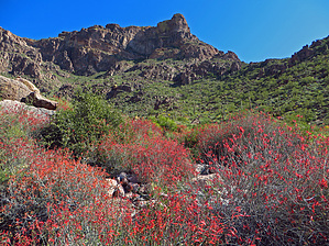


