Route Editor

| Guide | ♦ | 24 Triplogs | 0 Topics |
details | drive | permit | forecast | 🔥 route |
stats |
photos | triplogs | topics | location |
| 75 | 24 | 0 |
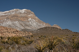
The ultimate Red Rock sampler hike by writelots Start at the Willow Springs parking area and you'll get the climb over with at the beginning, leaving you a downhill stretch to view some of the best of the signature red rock scenery. You'll start off climbing gently through the high desert, roughly parallel to the scenic drive (but never in sight of it). When you come to a fork with a sign reading "White Rock Springs 2.2 miles", take the uphill trail to the left. A short hike up is the spur trail which leads to a cool wash bed where you can view the Keyhole Thrust phenemenon up close (that spur would add roughly 2 miles to your hike). As you hike around the back of the White Rock mesa, you'll get treated to the northern slope vegetation - with twisted junipers and pines, as well as an intermittent stream just a short ways off the trail (a seasonal waterfall may even be visible on the opposite canyon wall). Then, as you circle around to the west side, you get treated to views down the long canyon and up to the peaks - some at over 7000' can be snow covered much of the winter! The final junction is with an old (and still lightly used) jeep road. Heading uphill would take you to La Madre Springs - another spur if you want to add mileage. Head downhill here to return to the Willow Springs parking area via the paved road or the side trail across the large wash.
Check out the Official Route and Triplogs. Leave No Trace and +Add a Triplog after your hike to support this local community. | ||||||||||||||||||||||||||||||||||||||||||||||||||||||||||||||||||||||||||||||||||||