username
X
password
register
for free!
help
  This is likely a great time to hike this trail!  Check out "Preferred" months below, keep in mind this is an estimate.
  🔥

Chevelon Creek - Larson Ridge Route, AZ

Guide 18 Triplogs  0 Topics
  3.7 of 5  
Fav
Wish
3
details
drive
no permit
forecast
🔥
route  
stats
photos
triplogs
topics
location
249 18 0
Statistics
tap row or icons for details
Difficulty 4 of 5
Route Finding 3 of 5
Distance One Way 0.94 miles
Trailhead Elevation 7,349 feet
Elevation Gain -847 feet
Accumulated Gain 24 feet
Avg Time One Way 30 min
Kokopelli Seeds 1.02
 Interest Off-Trail Hiking, Seasonal Creek & Perennial Creek
feature photo
Photos Viewed All MineFollowing
Inaugural Calculation on Button Tap!
3  2024-09-01 diablo
22  2023-09-16
Chevelon Wanderings
The_Eagle
15  2023-09-16
Chevelon Wanderings
chumley
45  2020-08-12 outdoor_lover
3  2019-08-03 ALMAL
6  2018-06-09 MountainMatt
5  2018-06-09
Willows Springs Lake / Larson Ridge
topohiker
8  2018-05-26 ALMAL
Page 1,  2,  3
Author
author avatar Guides 16,843
Routes 17,472
Photos 24
Trips 1 map ( 6 miles )
Age 28 Male Gender
Location HAZ, TrailDEX
Associated Areas
list map done
Payson Region
Historical Weather
Trailhead Forecast
Radar Map
Expand Map
Preferred May, Sep, Oct, Jun
Sun  5:59am - 6:46pm
Official Route & 3 Rts
 
2 Alternative
 
Historic Fire Perimetersacres
🔥 2017 Slim Fire3.2k
🔥 2002 Rodeo-Chediski Fire233.5 mi**
🔥 View (All) - over Official Route 🔥
*perimeter length in miles
**possible voids inflate figure


remove free decal offer

  Likely In-Season!
Guide Needed
Publish Full Detail Guide


Use +Add above to share photos and triplogs
Access to Chevelon Creek from the end of FR 237 (Larson Ridge) via a very steep but well-traveled route.
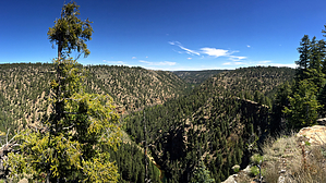
Happy

Trails!


    Check out the Official Route and Triplogs.

    Note
    This is a moderately difficult hike.
    Leave No Trace and +Add a Triplog after your hike to support this local community.

    One-Way Notice
    This hike is listed as One-Way.

    When hiking several trails on a single "hike", log it with a generic name that describes the hike. Then link the trails traveled, check out the example.
    WARNING! Hiking and outdoor related sports can be dangerous. Be responsible and prepare for the trip. Study the area you are entering and plan accordingly. Dress for the current and unexpected weather changes. Take plenty of water. Never go alone. Make an itinerary with your plan(s), route(s), destination(s) and expected return time. Give your itinerary to trusted family and/or friends.

     Permit $$
    None


     Directions
    or
     Road
    High Clearance possible when dry

    To hike
    Turn north on FR 237 1/4 mile west of Canyon Point Campground and 2 miles west of Forest Lakes. This is approximately 34 miles east of Payson on AZ-260. Travel FR 237 for 7.5 miles from AZ-260 until it ends or becomes impassable and begin the hike there.
    page created by chumley on May 17 2015 10:17 pm
     90+° 8am - 6pm kills
    helpcorrectionissue

    end of page marker