Route Editor

| Guide | ♦ | 1 Triplog | 0 Topics |
details | drive | permit | forecast | route |
stats |
photos | triplog | topics | location |
| 25 | 1 | 0 |
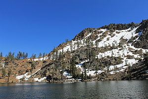
Long Hike To A High Alpine Lake by JimmyLyding The Trinity Alps Wilderness was created in 1984 to protect a remarkable 525,000-acre range of mountains that few Californians visit much less know exist. Yosemite has smog, and many of its campgrounds look like refugee camps. The Lake Tahoe region is overrun with people, and traffic jams are commonplace. However, the Trinity Alps are relatively deserted by comparison to those places. The high alpine lakes, deep forests and jagged peaks are enjoyed by few people. This hike starts at the Swift Creek trail head which is one of the more popular trail heads in the area. Allegedly the only other trail head that rivals Swift Creek for use is Canyon Creek (which I did during Memorial Day weekend 2014). The Swift Creek trail begins at the northwestern end of the parking area, and initially travels downhill for a quarter-mile through a nice forest of ponderosa pine and Douglas fir before quickly entering the wilderness area. The trail continues gently uphill for 3.2 miles and 1,150' to a crossing of Parker Creek. Red fir, incense cedar and western white pine are also present making this area a great place for conifer diversity. There are a few views to the south of the 7,000' ridges running east from Gibson Peak and Seven Up peaks, and their north-facing slopes had plenty of snow on May 23, 2015 when I hiked here.
Swift Creek perennially flows on the left/south side of the trail since the beginning, but it's rarely visible. It's more likely heard than seen, and is a constant reminder that you're hiking through a pretty good-sized drainage. Large Mumford Meadow is a popular camping spot 5.75 miles in, and indeed there are numerous nice camping spots on the creek side of the trail for the previous mile to this point. The hike has been mellow to this point with 5.7 miles and 1,500 feet of elevation gain, but it's about to get a lot tougher. The Swift Creek trail continues up the drainage you've been in from the beginning to Horseshoe Lake and Ward Lake above it, and is a popular stretch. The Landers Lake trail goes goes north first through the meadow then steeply uphill for 2.25 miles and 1500' through an open forest of red fir to Landers Lake after passing the rough-looking Sunrise Creek trail about 2/3 mile up. The trail opens up towards its junction with the spur trail up to Landers Lake. There are a few meadows up the spur trail that were wet when I was there, and the best views of the hike are here. The high divide that separates the Swift Creek and Stuart Creek drainages is visible to the south, and the light is gorgeous in the late afternoon. Enjoy the short uphill stretch into the high basin with Landers Lake as it tops a rise then basically ends about 30 yards from the lake. The north-facing wall of Red Mountain dominates the view beyond the 25-acre lake, and had a lot of snow when I was there. The views of the lake and Red Mountain are phenomenal, and everything you'd want for the midpoint of a long hike. This is a semi-popular backpacking camping area as well, and water is easily available. You'll have many options for seating on the large rocks surrounding the lake underneath the trees. However, it was pretty buggy when I was there. There are some unofficial trails up in the high basin just above the lake that skirt 2 smaller lakes and lead up to a small divide with great views of Foster Lake down in a deep basin with Sugar Pine Butte and Thumb Rock towering a few miles away above the myriad forested canyons that bless this area. Return the way you came after enjoying the views This area is commonly referred to as the Trinity Alps, but it's actually in the Salmon Mountains which themselves are part of the Klamath Mountains. Return the way you came or go left on the Landers Lake trail to continue on to the Parker Creek trail. Backpacking is popular here, and a free campfire permit is required. These permits can be obtained at the Forest Service office in Weaverville. Check out the Official Route and Triplog. Note This is a moderately difficult hike. Leave No Trace and +Add a Triplog after your hike to support this local community. | ||||||||||||||||||||||||||||||||||||||||||||||||||||||||||||||||||||||||||||||||||||||||||||||||