username
X
password
register
for free!
help


Smith Peak, AZ

Guide 10 Triplogs  0 Topics
  3.3 of 5  
Fav
Wish
1
details
drive
permit
forecast
route  
stats
photos
triplogs
topics
location
119 10 0
Statistics
tap row or icons for details
Difficulty 3 of 5
Route Finding 2 of 5
Distance Round Trip 6.01 miles
Trailhead Elevation 3,333 feet
Elevation Gain 1,979 feet
Accumulated Gain 2,227 feet
Avg Time Round Trip 3.5 hours
Kokopelli Seeds 17.15
 Interest Off-Trail Hiking & Peak
 Backpack Possible - Not Popular
unreported if dogs are allowed
editedit > ops > dogs to adjust
feature photo
Photos Viewed All MineFollowing
Will recalculate on button tap!
15  2022-01-21 PatrickL
25  2020-12-13
Harcuvars: Spade - Smith - Bullard
DixieFlyer
42  2017-11-21
Harcuvar and Bullard
FLYING_FLIVER
17  2017-11-18 Jim
11  2013-12-28 desert_boonie
9  2009-02-20 sbkelley
Author
author avatar Guides 6
Routes 13
Photos 1,377
Trips 184 map ( 1,895 miles )
Age 41 Male Gender
Location Reno, NV
Associated Areas
list map done
Southwest Region
Historical Weather
Trailhead Forecast
Radar Map
Expand Map
Preferred Apr, Oct, Mar, Nov → Early
Seasons   Late Autumn to Late Spring
Sun  6:09am - 6:54pm
Official Route & 2 Rts
 
2 Alternative


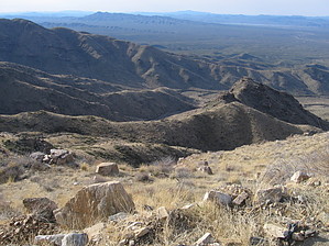
Old Road Route to the high point of the Harcuvars
by sbkelley

  
Overview
A hike to the top of a remote desert peak in the Harcuvar Mountains. Follow an old track to a dirt road to take in the views.


Hike
This one is a fairly straightforward hike to the highest point in Western Arizona's remote Harcuvar Mountains. Depending on where you parked, you should see an old dirt road track heading steeply up the southern face of the mountain directly in front of you. This road track is incredibly steep and sees little to no vehicle traffic, so your heart rate will get going in a hurry. Brush and loose rocks are frequent. You will gain elevation quickly in this stretch as this old track angles towards the main ridge of the Harcuvars east of Smith Peak. The angle doesn't relent until you get to this point, where you'll run into the well-graded dirt road leading to the towers atop the peak. From here, the peak is only a few hundred feet above you but still 1.5 miles away. Walk along the dirt road along the crest of the Harcuvars and take in the views in both directions - nothing will block your view. You may have to dodge an occasional service vehicle heading to and from the summit towers. The road does lose some elevation in stretches before finally heading up the summit proper. This makes for a great half-day hike and offers a glimpse of a part of the state that sees little traffic.
remove free decal offer
Water Sources
None. Bring plenty.

Camping
A few primitive campsites were around. We started at a fire pit at our parking spot and saw a few spots along the road. Check with the Lake Havasu Field Office for regulations, but the area sees little visitation.

2009-02-23 sbkelley


    Check out the Official Route and Triplogs.
    Leave No Trace and +Add a Triplog after your hike to support this local community.
    WARNING! Hiking and outdoor related sports can be dangerous. Be responsible and prepare for the trip. Study the area you are entering and plan accordingly. Dress for the current and unexpected weather changes. Take plenty of water. Never go alone. Make an itinerary with your plan(s), route(s), destination(s) and expected return time. Give your itinerary to trusted family and/or friends.

     Permit $$
    See BLM Data Above


     Directions
    or
     Road
    Strictly 4x4

    To hike
    Drive west on US 60 from Wickenburg or east on US 60 from Salome. Reach the small town of Aguila and travel north on the Eagle Eye Road. Follow this road as the pavement turns to dirt. Soon a sign will say "Leaving Maricopa County", and the road swings west. Follow this until you see a road paralleling utility lines heading towards the peak. Follow this road as far as you feel comfortable. High clearance and 4WD are highly recommended. See Smith Peak road log posted by davis2001r6 for the GPS route.
    page created by sbkelley on Feb 23 2009 10:24 pm
     90+° 8am - 6pm kills
    helpcorrectionissue

    end of page marker