username
X
password
register
for free!
help
 This is likely a great time to hike this trail!  Check out "Preferred" months below, keep in mind this is an estimate.
 

Target & Ballroom Cave Ruins, UT

Guide 10 Triplogs  0 Topics
  4.3 of 5  
Fav
Wish
1
details
drive
no permit
forecast
route  
stats
photos
triplogs
topics
location
92 10 0
HAZ reminds you to respect the ruins. Please read the Archaeological Resources Protection Act of 1979 & Ruins Etiquette
Statistics
tap row or icons for details
Difficulty 1 of 5
Distance Round Trip 2.25 miles
Trailhead Elevation 5,212 feet
Elevation Gain 225 feet
Kokopelli Seeds 3.38
 Interest Ruins & Perennial Creek
unreported if dogs are allowed
editedit > ops > dogs to adjust
feature photo
Photos Viewed All MineFollowing
Inaugural Calculation on Button Tap!
14  2022-05-07 Yoder
15  2022-05-07 Yoder
8  2022-04-27 AZLOT69
15  2022-01-09 Stoic
20  2018-04-15 Steph_and_Blake
10  2018-04-15 Steph_and_Blake
49  2018-04-13
Nine Days - Cedar Mesa Comb Ridge (Part 2)
AZWanderingBear
3  2015-05-22 AZLOT69
Page 1,  2
Author
author avatar Guides 16,843
Routes 17,472
Photos 24
Trips 1 map ( 6 miles )
Age 28 Male Gender
Location HAZ, TrailDEX
Associated Areas
list map done
Southeast Region
Historical Weather
Trailhead Forecast
Radar Map
Expand Map
Preferred May, Oct, Apr, Sep → 7 AM
Sun  5:51am - 6:43pm
Official Route & 1 Rt
 
0 Alternative


remove free decal offer

 Likely In-Season!
Guide Needed
Publish Full Detail Guide


Use +Add above to share photos and triplogs
Seldom visited ruins in a side canyon. Opposing alcoves with ruins on both sides of the box canyon.

Happy

Trails!


    Check out the Official Route and Triplogs.
    Leave No Trace and +Add a Triplog after your hike to support this local community.
    WARNING! Hiking and outdoor related sports can be dangerous. Be responsible and prepare for the trip. Study the area you are entering and plan accordingly. Dress for the current and unexpected weather changes. Take plenty of water. Never go alone. Make an itinerary with your plan(s), route(s), destination(s) and expected return time. Give your itinerary to trusted family and/or friends.

     Permit $$
    None


     Directions
    or
     Road
    Paved - Car Okay

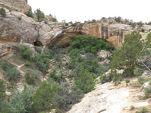
    To hike
    Go south out of Blanding about 3.5 miles until the junction with highway 95. Follow highway 95 about 10.6 miles until crossing a bridge over Butler Wash. The tralhead is just east of the Buter Wash Ruins rest area.
    page created by AZLOT69 on Jun 04 2015 9:59 am
     90+° 8am - 6pm kills
    helpcorrectionissue

    end of page marker