 Route Editor

| Guide | ♦ | 6 Triplogs | 1 Topic |
details | drive | permit | forecast | 🔥 route |
stats |
photos | triplogs | topic | location |
| 39 | 6 | 1 |
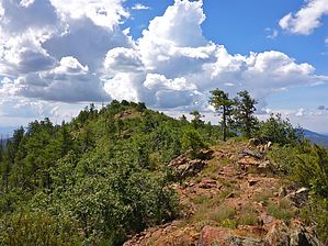
Da Comrade by kingsnake  Overview OverviewLast year, when I was up in the tower on Mount Union, I noticed a small peak about a mile south, which turned out to be Moscow Peak. From various triplogs and routes, HAZ'rs had been all around it but never actually up to it. The peak itself does not stand out much -- it is only about 400 ft. above Trail #284 -- but is easy to pick out due to being at the end of a ridge and having a relatively bald summit. The summit views are fantastic. Hike From Five Corners, head west up FR 261. At 0.6 miles, you will cross Dandrea Trail #285. At 1.6 miles, turn south onto Yankee Doodle Trail #284. You will have climbed 900 exposed feet, but now the trail descends slightly and becomes quite shady and cool. At about 2.0 miles, just before a 15 ft. rock wall appears on your left, turn left up a small draw. There will be some cairns and footpaths as you head SSE. Generally, pick your way through the open areas, and you will be heading in the correct direction. You will reach the summit of just over 7000 ft. at 2.4 miles. After enjoying the views, work your way south off the summit. The south is rockier and steeper but is an easy descent. (For a shorter hike, return the way you came.)
4.80 mi.: FR 83 and Orofino Mine, of which not much remains, other than scattered bits of metal and wood. The shaft and/or adit locations are obvious but long since filled in. Head north on FR 83. From this point until just past Dandrea Ranch, the hike is quite shaded. In a mile, the Mastodon Mine is just to your right. I'm not sure if anything remains there, as the location is so anonymous that we walked right past it, none the wiser. 6.40 mi.: FR 83 splits left towards a gated claim. (I'm not sure how someone can legally fence off an official NFS road, but there you go.) FR 9404V splits right, down towards Turkey Creek. The claim looks at least semi-occupied -- even if only by bears -- so you will probably want to take 9404V, which climbs up to just below the rim of Big Bug Mesa. At 7.0 miles, turn north on FR 9404W. At 8.6 miles, there is a foot trail, back and to the right, which goes to the top of Big Bug Mesa, just south of Hill 7020. 8.80 mi.: You will pass by two check dams, one on each side of FR 9404W, as you approach Dandrea Ranch, which is a flat, cleared area surrounded by collapsed stone walls and scattered bits of barb wire fence. Be bummed the NFS did not leave any historic buildings at the ranch. At 9.4 miles, you will cross the south end of Dandrea Trail #285 before returning to the Five Corners TH at 10.0 miles. Gate Policy: If a gate is closed upon arrival, leave it closed after you go through. If it is open, leave it open. Leaving a closed gate open may put cattle in danger. Closing an open gate may cut them off from water. Please be respectful, leave gates as found. The exception is signage on the gate directing you otherwise. Check out the Official Route and Triplogs. Leave No Trace and +Add a Triplog after your hike to support this local community. One-Way Notice This hike is listed as One-Way. When hiking several trails on a single "hike", log it with a generic name that describes the hike. Then link the trails traveled, check out the example. | ||||||||||||||||||||||||||||||||||||||||||||||||||||||||||||||||||||||||||||||||||||||||


