Route Editor

| Guide | ♦ | 4 Triplogs | 0 Topics |
details | drive | no permit | forecast | route |
stats |
photos | triplogs | topics | location |
| 4 | 4 | 0 |
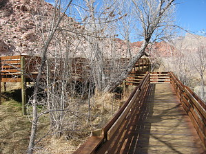
Under The Boardwalk by AZLOT69  Hike: The boardwalk starts from the paved parking area which is equipped with restrooms but no water. The trail is handicap accessible with most of the hundred foot gain of elevation at the beginning. Hugging the base of these towering dunes, the boardwalk gets you close enough to see the effect of what iron rich coatings on grains of sand and calcium carbonate from water has done to these dunes both bleaching the rock white accented with the deepest reds resulting in patterns of red spots, bumps and marbles. There are several petroglyphs and pictographs on the south facing walls. Red Spring is alive with plant and animal life that has been drawn to this oasis for millions of years. The water filters thru the sandstone from melting mountain snows in the Spring Mountains to the west. The area is thick with aquatic plants, frogs, toads, and snails. Evidence abounds which supports occupation of this area by prehistoric people. Several hunting weapons, tools, pottery, and metates have been located. The boardwalk also passes by cement foundations of settlers from the mid 1800s who had vast cattle ranches taking advantage of the spring water. Several cottonwood trees provide comfortable shade for those interested in bird watching from many available benches along the loop. Check out the Official Route and Triplogs. Leave No Trace and +Add a Triplog after your hike to support this local community. | ||||||||||||||||||||||||||||||||||||||||||||||||||||||||||||||||||||||||||||||||||