Route Editor

| Guide | 0 Triplogs | 0 Topics |
details | drive | no permit | forecast | map |
stats |
photos | triplogs | topics | location |
| 14 | 0 | 0 |
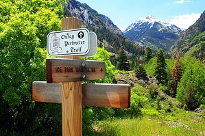
Uncompahgre Ice Box by PrestonSands The Ice Park Trail #196, also known as the Ice Park Loop, is a short, easy, 2-mile loop hike with minimal elevation change, right on the edge of Ouray. In summer, this is a pleasant water course hike, along the raging Uncompahgre River gorge. During the winter, this is largely the domain of ice climbers. History In places, the Ice Park Trail follows the route of a historic "penstock" water pipeline, constructed during the late 19th century to supply water to Ouray's hydroelectric plant. Otto Mears' historic 19th-century toll road to Silverton passed through this area, likely along the east side of the loop.
This hike is a loop, connected by a few hundred feet of the Camp Bird Mine Road. Start at either end of the trail. The two starting points are on either side of the Uncompahgre River bridge. Hiking the trail clockwise, by starting at the first trailhead on the Ouray side of the bridge, makes this hike a little easier, as the trail is better signed going in this direction. This description is of a clockwise hike of the loop. Starting at the first trailhead on the Ouray side of the Uncompahgre River bridge on Camp Bird Mine Road, the Ice Park Trail climbs the hill above the road, heading east. The trail heads east and then southeast, along an open, rocky, shelf-like area, below Highway 550, and above the Uncompahgre River. About a half-mile in, the trail enters the forest and begins to descend toward the canyon bottom. The Ice Park Trail crosses the Uncompahgre River on a wooden bridge above raging whitewater and then climbs up the west side of the canyon a bit. Encountering the hydroelectric plant pipeline, the Ice Park Trail turns northwest to follow a closed road back down the canyon, generally staying close to the pipeline. There are some nice views of the rugged gorge and Mount Abrams to the south along this stretch of the hike. You'll pass signs for the Ouray Ice Park trails, and a few associated structures along the way, but keep following the pipeline road. After passing a small lake, the Ice Park Trail makes a short descent through the forest and ends up back at the Camp Bird Mine Road and Ouray Ice Park parking lot. Cross the Uncompahgre River bridge, and you will be back at your starting point. Water Sources There is permanent water in the Uncompahgre River. Don't fall in; you'll get a free ride back into Ouray, either by creek or ambulance. Camping Camping is not allowed along Camp Bird Mine Road, or in the Ouray Ice Park area. Leave No Trace and +Add a Triplog after your hike to support this local community. | ||||||||||||||||||||||||||||||||||||||||||||||||||||||||||||||||||||||||||||||||||||||||||