Occasional wildlife paths parallel this drainage along an intermittent stream. It is primarily open and grassy but can be narrow and overgrown with rocky footing in some stretches.
Stats reflect travel from FR300 to the junction with Beaver Canyon. You can continue to follow Turkey Creek downstream an additional mile to FR91 road access at McGuire Crossing or an extra 3.5 miles to its terminus at Gentry Canyon.
When hiking several trails on a single "hike", log it with a generic name that describes the hike. Then link the trails traveled, check out the example.
WARNING! Hiking and outdoor related sports can be dangerous. Be responsible and prepare for the trip. Study the area you are entering and plan accordingly. Dress for the current and unexpected weather changes. Take plenty of water. Never go alone. Make an itinerary with your plan(s), route(s), destination(s) and expected return time. Give your itinerary to trusted family and/or friends.
Permit $$
None
Directions
Road
FR / Dirt Road / Gravel - Car Okay
To hike Hike begins at the high-voltage power lines where they cross FR 300 about 16 miles west of Hwy 260.
 Route Editor

 This is NOT A TRAIL!
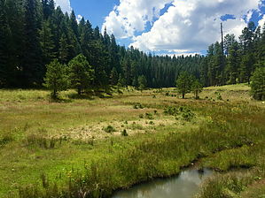


